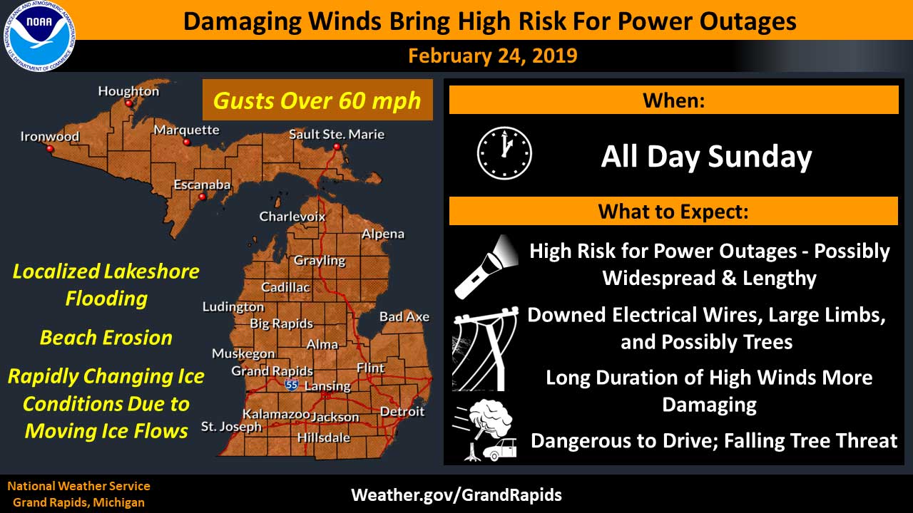
The National Weather Service has issued a High Wind Warning in effect from 7 AM Sunday to 7 AM Monday for all of South Central Michigan. Hazardous weather will include wind gusts of up to 55 to 65 mph Sunday through Sunday evening along with blowing snow.
Impacts may include numerous power outages likely with downed trees, tree limbs and power lines. Prolonged power outages are possible.
Consumers Energy is closely monitoring winter weather across the Lower Peninsula. Consumers Energy is mobilizing resources and making other preparations to respond to service interruptions.
To help the public prepare for what to do before, during and after a storm, Consumers encourages customers to visit www.ConsumersEnergy.com/OutageCenter for helpful tips. These include the safe operation of generators and staying at least 25 feet away from any downed power lines. At the outage center website, customers also can visit the online outage map, report an outage and sign up to receive power restoration updates.
A High Wind Warning means a hazardous high wind event is expected or occurring. Sustained wind speeds of at least 40 mph or gusts of 58 mph or more can lead to property damage. Scattered thunderstorms are expected mid to late this evening. While severe weather is not forecast, a few wind gusts in excess of 45 mph will be possible.
Strong and likely damaging winds will sweep across the area Sunday morning and continue into Sunday night. Wind gusts may reach 65 mph. Downed trees and tree limbs onto power lines will create power outages, some of which could last days.
Lake effect snow showers will commence Sunday and continue into Sunday night. Accumulations of an inch or two over southern lower Michigan. Blizzard conditions are forecast across central and northern lower Michigan Sunday and Sunday night with frequent whiteout conditions. Snow and blowing snow will result in significantly reduced visibility at times elsewhere.
The forecast for Saturday night: Showers and thunderstorms. Areas of fog between 7pm and 4am. Temperature rising to around 51 by 4am. Southeast wind 11 to 17 mph becoming south southwest after midnight. Winds could gust as high as 30 mph. Chance of precipitation is 90%. New rainfall amounts between a quarter and half of an inch possible.
Sunday’s Forecast: High Wind Warning 7 AM Sunday to 7 AM Monday. Rain showers before 11am, then rain and snow showers likely between 11am and 2pm, then a chance of snow showers after 2pm. Temperature falling to around 29 by 5pm. Windy, with a west wind 18 to 23 mph increasing to 27 to 32 mph in the afternoon. Winds could gust as high as 60 mph. Chance of precipitation is 80%. New snow accumulation of less than a half inch possible.
