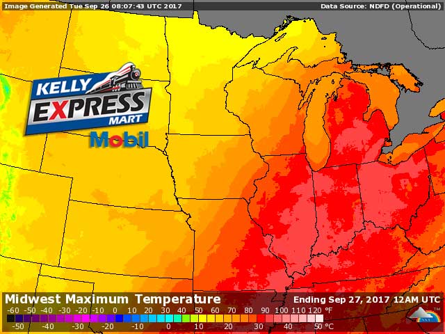
One more day of record to near record highs in the upper 80s to lower 90s. A cold front comes through the area early tonight with only scattered showers and perhaps an isolated thunderstorm. This will lower our high temperatures on Wednesday nearly 25 degrees from todays values. This will only brings afternoon temperatures to near normal values. A second cold front on Friday brings in the truly cold air. Temperatures will by then be chilly. Another warming trend follows by early next week.
Today: Sunny. Highs around 90. Southwest winds 5 to 10 mph.
Tonight: Partly cloudy. Lows in the lower 60s. Southwest winds around 5 mph becoming west overnight.
Wednesday: Partly sunny until midday then clearing. Highs in the mid 70s. Northwest winds 10 to 15 mph.
Wednesday Night: Mostly clear. Lows in the mid 40s. North winds 5 to 10 mph. Gusts up to 20 mph in the evening.
Thursday: Sunny. Highs in the upper 60s. Northwest winds 5 to 10 mph.
Thursday Night: Partly cloudy with a 40 percent chance of rain showers. Lows in the upper 40s.
Friday: Partly sunny until midday then becoming mostly sunny. A 20 percent chance of rain showers. Highs in the mid 60s.
Yesterday’s high was 91 (new record high, fifth consecutive day) at 2:23 PM. The low was 62 at 5:17 AM.
Average temperature for today is 68. The record high is 90 set in 1998, record low is 35 set in 1965.
0.00 inches of of precipitation yesterday. Total precipitation for the month: 0.64 inches.
Sunrise today at 7:30 AM EDT. Sunset at 7:28 PM EDT.