The Michigan Department of Transportation (MDOT) has released the 2017 Paving the Way state construction map online for motorists to download.The public is encouraged to download the map and print it at home or at their nearest library or print service provider. The map is available at www.michigan.gov/mdotmaps, and will also be on display in all rest areas and Welcome Centers across the state.
“Using current technology to make our yearly construction map available to download is a great service to travelers planning ahead,” said State Transportation Director Kirk T. Steudle. “We want motorists to remember to slow down in construction zones and avoid all distractions. While you’re trusting workers to improve the roads, they’re trusting you with their lives to drive safely and responsibly in their work area. We want everyone to make it home each and every night.”
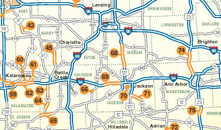
Construction projects in the South Central Michigan area for 2017 include:
66. M-99 South Superior Street: April-November
Reconstruct 0.4 miles from Ash Street to Vine Street in Albion. Closed and detoured.
68. US-127: May-September
Resurface 17.2 miles from Henry Road to M-36. One lane open in each direction.
69. I-94: May-August
Patch concrete 7.4 miles from west of Michigan Avenue to M-60. One lane closed 10am Mondays to 2pm Thursdays.
70. I-94 Business Loop/M-50 Michigan Avenue: April to November
Reconstruct 1.2 miles from Brown Street to Louis Glick Highway/Washington Avenue split, upgrade for 2-way traffic from split to Cooper Street in downtown Jackson. One lane open in each direction, westbound detour.
71. M-50: May-October
Resurface 6 miles from US-127 to Napoleon Road. Flag control. All lanes open during race weekends at MIS.
The most up-to-date construction information for state roads is always available on the Mi Drive traffic website at www.michigan.gov/drive, as well as the Mi Drive mobile app, available on iTunes and Google Play.