
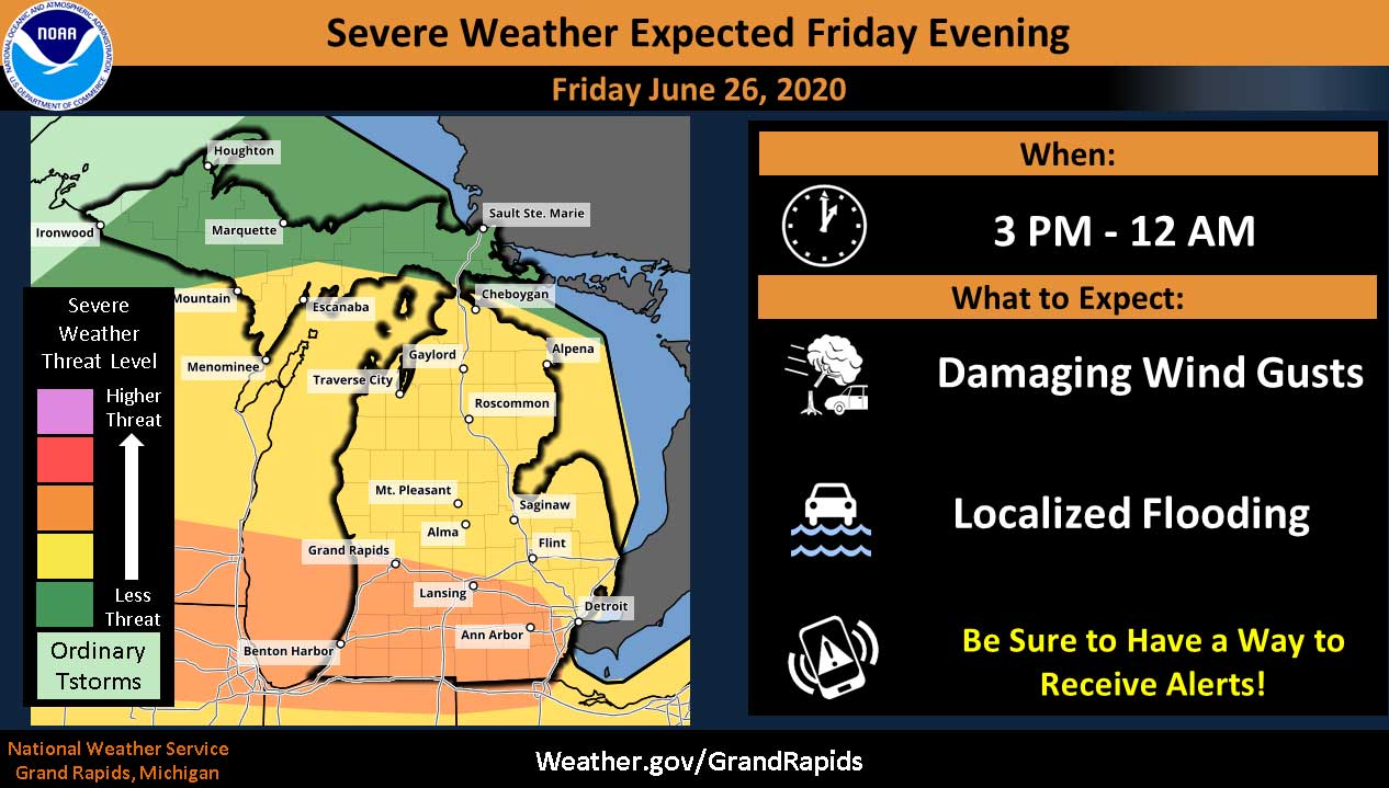
Threat for Severe Storms this Afternoon and Evening
(June 26, 2020 11:45 AM) Strong to severe thunderstorms are possible this afternoon and evening between roughly 4 PM and midnight according to the National Weather Service. Damaging winds will be the main threat as lines of storms sweep from west to east. Winds in excess of 60 mph are possible. The strongest of storms will also be capable of large hail and an isolated tornado. Locally heavy rain is expected as well...with the possibility of flooding. A warm front will be pushing into southern lower Michigan this afternoon followed by a cold front tonight into Saturday. The threat of severe weather remains into early Saturday morning. Consumers Energy is prepared to respond to high winds and strong thunderstorms expected later today and tonight across Michigan, especially in southern portions of the state. Thunderstorms with wind gusts up to 65 mph could produce downed wires and power outages. Consumers Energy says response crews will be taking COVID-19 precautions such as practicing social distancing in their vehicles and other work locations, completing medical screening prior to their shift and regularly cleaning vehicles and other work surfaces. While Consumers Energy greatly appreciates residents who often come out of their homes to talk when…

JCDOT May 19 Road Flooding Report
PhotoGraphic: Jackson County Department of Transportation (May 19, 2020 6:16 PM) The Jackson County Department of Transportation (JCDOT) has been proactively monitoring and responding to storm damage on county roads throughout the day. The following locations have water over the road and new roads have been added: Boardman Road – Blackman Township – OPEN Buckman Road between Moscow Road and Snow Road – Hanover Township Browns Lake Road – Summit Township Clark Lake Road between Reed Road and S. Stoney Lake Road – CLOSED Callahan Road at Michigan Avenue – Parma Township Dearing Road at Maci Road – Sandstone Township – Clear & Ok Golfview Road – Columbia Township Hankerd Road – Henrietta Township – Clear & Ok Idle Hills Road – Norvell Township Kimmel Road east of S. Jackson – Summit Township – Clear & Ok Kinch Road – Henrietta Township – Clear & Ok Lee Road – Leoni Township Lippert Road east of Eckert Road – Pulaski Township Lowell Street – Blackman Township – Clear & Ok Michigan Avenue near Glasgow Road – Sandstone Township Portage Road – Leoni Township Reed…
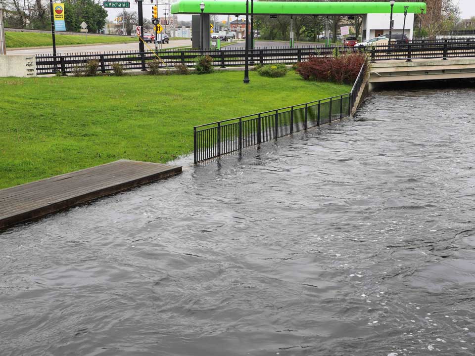
Flood Warning Continues Through Monday, May 25
The Grand River, at Glick and Mechanic, Downtown Jackson Tuesday morning. JTV photo. (May 19, 2020 11:28 AM) The National Weather Service is continuing the Flood Warning for the Grand River at Jackson affecting Jackson County. Up to 4 inches of rain has fallen across the bulk of Southern Lower Michigan over the last 48 hours. Falling on wet soil, this has pushed many rivers above flood stage. The Flood Warning continues for the Grand River at Jackson until Monday, May 25. At 5:30 PM Monday the stage was 14.2 feet. Flood stage is 14.0 feet. Minor flooding is occurring and minor flooding is forecast. The river is forecast to rise again today and likely surpass flood levels again Wednesday afternoon. The impact, at 14.0 feet, expect minor flooding of low lying areas. This crest compares to a previous crest of 14.6 feet on Sep 2 2018.

National Weather Service Issues Wind Advisory for Monday
(April 12, 2020 4:33 PM) The National Weather Service has issued a Wind Advisory in effect from 8 AM to 8 PM Monday for all of Southern Lower Michigan. A Lakeshore Flood Warning is in effect for all West Michigan counties along Lake Michigan. Wind gusts over 50 MPH are expected on Monday. Impacts may include: tree limbs and power lines could come down and scattered power outages are expected. Winds this strong can make driving difficult, especially for high profile vehicles. Use extra caution. Winds will increase significantly Monday morning around daybreak. Wind gusts of around 50 mph are expected on Monday, with gusts up to 60 mph possible. These winds are expected to cause scattered power outages, some downed tree limbs and power lines, and will cause loose objects to be blown around. Consumers Energy is prepared to respond and is reminding customers they are committed to the health and safety of their co-workers, customers and communities as they work on restoring power. Response crews will be taking COVID-19 precautions such as practicing social distancing in their vehicles and other work locations, completing medical screening prior to their shift and regularly cleaning vehicles and other work surfaces.…

Several County Roads Flooded Following Heavy Rain
Smith Road in Leoni Township. JCDOT Photo. (March 28, 2020 4:32 PM) Following heavy overnight rainfall, the Jackson County Department of Transportation is reporting flooding on county roads throughout the day. The National Weather Service says one to two inches fell on the area overnight and more rain is expected JCDOT is monitoring conditions on county roads and erecting safety barriers where necessary. These locations have water over the road: Boardman Road (westbound, Maynard to Airport) – Blackman Township – westbound lane CLOSED Browns Lake Road – Summit Township Callahan Road at Michigan Avenue and Miner Road – Parma Township Dearing Road at Maci Road – Sandstone Township Golfview Road – Columbia Township Harr Road – Waterloo Township Lippert Road east of Eckert Road - Pulaski Township Owens Road – Norvell Township Smith Road – Leoni Township – CLOSED The westbound lanes of Boardman Road (between Maynard and Airport Road) and Smith Road are both currently closed and will remain closed until water levels recede and the roads are deemed safe for traffic. Detour routes will not be posted and motorists should seek alternate routes. Motorists are reminded to never drive through standing water, as the integrity of the underlying…
Additional 2-4 Inches of Snow Expected Today as Advisory Continues
The National Weather Service is continuing the WINTER WEATHER ADVISORY in effect until 7 PM tonight for Jackson County and portions of southern lower and southwest lower Michigan. Areas to our east, including Washtenaw, Wayne and Lenawee Counties are under the advisory until 12 Midnight. Additional snow accumulations of 2 to 4 inches expected. Plan on slippery road conditions. The hazardous conditions will impact the morning and evening commutes. Snow will diminish for a time early this morning, but increase again during the morning hours. The heaviest snow is expected this afternoon, where the evening commute could be slowed considerably. Gusty north winds may lead to some areas of blowing snow as well.

Winter Weather Advisory Continues, Snow Spreads Throughout Area
The National Weather Service is continuing the WINTER WEATHER ADVISORY in effect until 7 PM Wednesday. Snow continues to fall from Holland to Grand Rapids just north of Lansing. This area of snow should weaken after midnight. This first area of snow will bring 1 to 2 inches of snow by the time it weakens during the early morning hours of Wednesday. The more significant snowfall is the second area of snow that moves into the advisory area around sunrise. The second period of snowfall moves into the I-94 and I-69 corridor by sunrise. That period of snowfall is expected to bring the 3 to 6 inches of snow with gusty winds and falling temperatures. Snowfall on Wednesday is expected to be heavy at times with gusty winds resulting in some blowing and drifting snow. Plan on snow covered roads with low visibility during the daytime hours of Wednesday. Anticipate slowing travel on area roads. The conditions will be hazardous through the daytime hours of Wednesday, however conditions will be significantly more impacted during the afternoon and evening. The storm will intensify Wednesday resulting in increasing winds. This will lead to periods of near zero visibility due the combination of…

Winter Storm Watch Beginning Tuesday Afternoon
The National Weather Service has issued a WINTER STORM WATCH in effect from Tuesday afternoon through Wednesday evening. Total snow accumulations of 4 to 7 inches from Tuesday afternoon through Wednesday evening. The watch area includes Jackson County and portions of central, south central, southwest and west central Michigan. Impacts include travel difficulty, especially on Wednesday when temperatures drop and untreated roads become icy and snow covered. After some light rain and snow tonight, a better chance for accumulating snow will come Tuesday evening through Wednesday night. Rain will switch over to snow across Southern Lower Michigan tonight. Light accumulations from a dusting to around an inch are possible. Snow is expected across Southern Lower Michigan from Tuesday through at least Friday. A widespread snow is expected from Tuesday evening through Wednesday evening with amounts on the order of 3 to 6 inches. Lake effect snow is then expected from Wednesday night through Friday. Travel will be impacted mid to late this work week with the Wednesday morning and evening commutes of most concern.

Winter Weather Advisory This Evening Through Thursday
The National Weather Service has issued a WINTER WEATHER ADVISORY from 7 PM Wednesday through 7 PM Thursday. Snow is expected with total snow accumulations of 2 to 4 inches. The highest amounts are expected along and south of I-94. Plan on slippery road conditions. The hazardous conditions could impact the Thursday morning and evening commutes. A boost in northerly winds on Thursday will add some blowing and drifting snow with falling temperatures into the teens. Slippery travel will be the biggest impact. Temperatures will quickly drop into the teens by Thursday afternoon and single digits overnight into Friday. Widespread snow of 2 to 4 inches is possible across southwest lower Michigan by Thursday afternoon and evening. Lake effect snow will linger Thursday night into Friday. Travel conditions will be impacted Wednesday evening through Friday.