Quantcast
skip to Main Content

Winter Storm Warning in Effect Through Noon Tuesday

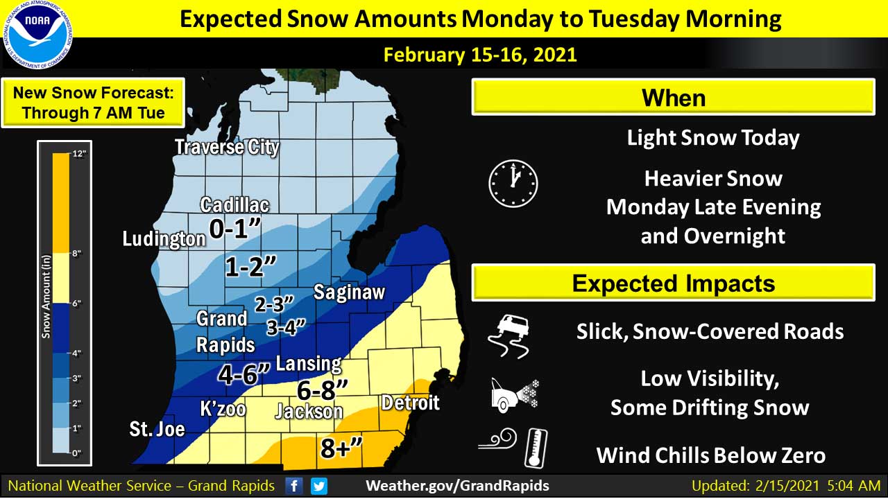
(February 15,2021 4:15 PM) The National Weather Service has issued a WINTER STORM WARNING in effect until Noon on Tuesday for Jackson and surrounding counties. Heavy snow is expected. Additional snow accumulations of 5 to 8 inches with locally higher amounts to 10 inches possible. Travel will be very hazardous starting this evening and lasting into Tuesday morning. Blowing snow could significantly reduce visibility and cause snow drifts on area roadways. Major impacts to the Tuesday morning commute are expected along with disruptions to normal activities potentially lasting throughout the day even after the snow ends. Wind chills today will be near zero degrees, and wind chills tonight will be about 10 degrees below zero, increasing the potential for frostbite. The National Weather Service says this will likely be one of the more impactful winter storm events of the winter so far. South central to southeast Michigan counties are in the warning area, along with the far southwest counties.  NWS is expecting 5 to 8 inches of snow east of a line from Alma to South Haven. There will be north to northeast winds of 10 to 20 mph with gusts to 30 mph, and wind chills in the 10…

Read more

Updated: Winter Weather Advisory In Effect Through Tuesday Noon

(February 15, 2021 9:58 AM) The National Weather Service has updated the WINTER WEATHER ADVISORY in effect now through 12 PM on Tuesday.  Light snow expected during the daytime hours on Monday.  Heavier snow beginning this evening and continuing overnight.   Temperatures will remain cold and wind chills of 0 to -10 expected. Light snow this morning will diminish by afternoon, then heavier snow arrives this evening into tonight. Additional snow accumulation of 4 to 7 inches are expected in southeastern sections of this advisory, including the areas near Kalamazoo, Battle Creek, Lansing, and Jackson. After a break in most of the snow Monday afternoon, additional snow moves in Monday night with snow covered roads and difficult travel. Slippery travel is possible for the Monday evening commute with hazardous travel developing Monday evening into the Tuesday morning commute for many areas. Periodic snow and very cold temperatures through Tuesday may create some travel impacts at times, especially along I-94. Subzero wind chill temperatures are likely on Monday, Tuesday, and Wednesday mornings. A system on Thursday night could also bring accumulating snow.    

Read more

Winter Weather Advisory from 7 PM Today to 8 AM Sunday

(February 6, 2021 8:50 AM) The National Weather Service has issued a WINTER WEATHER ADVISORY in effect from 7 PM this evening to 8 AM Sunday. Snow expected with total snow accumulations of an inch or two possible. Poor travel conditions due to cold temperatures and falling snow. The NWS says to plan on slippery road conditions.  Snow will spread this evening, after dark. The snow will be the heaviest between 7 PM and midnight.  Salt is less effective at temperatures in the single digits and teens which is what is forecast tonight. Poor travel conditions will result. Snow is expected both today and tonight, increasing in intensity this evening. Snow accumulations will range from 1 to 4 inches by Sunday morning. A combination of snow and cold will result in hazardous travel conditions. .

Read more

Winter Weather Advisory in Effect from 4 PM Today to 7 PM Friday

(February 4, 2021 7:25 AM) The National Weather Service has issued a WINTER WEATHER ADVISORY in effect from 4 PM this afternoon to 7 PM Friday.  Snow expected with total snow accumulations of 3 to 5 inches. Winds gusting as high as 40 mph late Thursday night and Friday. Rapidly falling temperatures Thursday night into the teens. Wind chills only around zero on Friday. The advisory is for portions of central, south central and southwest Michigan, including Jackson County. The Weather Service says to plan on slippery road conditions. Patchy blowing snow could significantly reduce visibility. Hazardous conditions may impact the Thursday evening commute, with worse conditions expected for the Friday commutes. The roads will become increasingly icy and snow covered Thursday night into Friday morning. Isolated power outages are possible. The snow may begin as a mix of rain and snow but will quickly change to all snow. The passage of the arctic front after midnight will causes the winds to increase significantly and will cause considerable blowing and drifting snow.  Snow will move into the area by late afternoon and will likely be heavy at times during the early to mid evening. Snowfall rates of up to an…

Read more

UPDATED: Winter Weather Advisory in Effect From 10 PM Saturday to 12 PM Sunday

Updated with new accumulation totals of 2 to 4 inches.  Advisory period changed, now 10 PM Saturday to 12 PM Sunday. (UPDATED January 30, 2021 4:19 PM)  The National Weather Service has issued a Winter Weather Advisory from 10 PM Saturday to 12 PM Sunday for southern lower and western Michigan, including Jackson County. Snow will spread into Southern Lower Michigan later this evening with bursts of moderate snow expected tonight. Snow will taper off on Sunday morning. Roads will become snow-covered and slippery tonight and continue at least into Sunday morning. The heaviest snow in the state will be towards the Michigan Indiana state line. Total snow accumulations range from 2 to 4 inches along Interstate 94.    The National Weather Service is expecting travel impacts along I-94 west of Jackson Saturday night and Sunday morning.  NWS says amounts could still shift a little higher or lower. The NWS is expecting very light snow will linger on Sunday at times; it just will not have the potential to add up to very much. The snow rates will be quite light in nature. In addition, temperatures will be warming to near freezing, which will limit the additional impacts on the…

Read more

Winter Weather Advisory in Effect Through Saturday Morning

(January 1, 2021 10:30 AM) The National Weather Service has issued a WINTER WEATHER ADVISORY in effect from 11 AM this morning to 6 AM Saturday. A mix of freezing rain, sleet, and snow is expected late this morning into the afternoon into late tonight. The best chance to see any freezing rain will be near and south of I-96, but the highest accumulations up to one-third inch are expected along the I- 94 corridor. Precipitation will change to all snow tonight. Total snow accumulations are expected to range from a dusting to two inches. Plan on slippery road conditions, especially during the afternoon and evening. Scattered power outages may occur this afternoon into Saturday morning.

Read more

Wind Advisory Issued for Tonight and Sunday

(November 14, 2020 2:43 PM) The National Weather Service has issued a Wind Advisory from 1 AM to 7 PM Sunday in effect for Jackson County and most of western lower Michigan. A strong fall storm system will develop and move through the area tonight and Sunday. Winds will increase tonight out of the south with gusts of 30 to 40 mph. Winds will increase substantially on Sunday out of the southwest and west with gusts of 45 to 55 mph posssible. Southwest winds are forecast at 20 to 30 mph with gusts up to 40 mph late tonight increasing on Sunday out of the west at 25 to 35 mph with gusts of 45 to 55 mph. Gusty winds could blow around unsecured objects.  Tree limbs could be blown down and a few power outages may result. Today, Consumers Energy said,  “This weather could result in power outages, downed wires, and other safety hazards. We are mobilizing resources to quickly respond to any service interruptions to keep you safe. Sign up for outage alerts by texting REG to 232273 (CECARE). Learn how you can safely prepare by visiting our Outage Center.” Use extra caution when driving, especially if operating…

Read more

Wind Advisory Issued for Late This Afternoon and Tonight

(November 10, 2020 11:49 AM) The National Weather Service has issued a Wind Advisory for Jackson County and all of southern and western lower Michigan.  The Wind Advisory is in effect from 4 PM this afternoon to 5 AM Wednesday.  Southwest winds 15 to 25 mph with gusts up to 50 mph  expected. Gusty winds could blow around unsecured objects.  Tree limbs could be blown down and a few power outages may result.  Use extra caution when driving, especially if operating a high  profile vehicle. Secure outdoor objects. A cold front that will be arriving in our area has already started to have an impact in northwestern lower Michigan where temperatures have dropped to the low 50s. The forecast for this evening and tonight:  A chance of showers and thunderstorms before 1am, then rain likely between 1am and 4am. Cloudy, then gradual clearing toward daybreak, with a low around 44. Breezy, with a south wind 18 to 21 mph becoming west after midnight. Chance of precipitation is 70%. New rainfall amounts between a tenth and quarter of an inch, except higher amounts possible in thunderstorms. Consumers Energy is monitoring today’s weather across Michigan’s Lower Peninsula, with increasing winds that could…

Read more

Severe Thunderstorm Watch in Effect Until Midnight

(August 10, 2020 6:04 PM)  The National Weather Service has issued a Severe Thunderstorm Watch for much of southern lower Michigan, including Jackson County.  Severe thunderstorms capable of producing wind gusts over 70 mph  are possible this evening. The greatest threat will be south of  the I-96 corridor. Wind damage to trees and structures is possible. Power outages are also a concern.  The Severe Thunderstorm Watch is in effect until 12 AM. Consumers Energy issued a statement this afternoon, anticipating severe weather: “According to the National Weather Service, damaging wind gusts up to 60 mph are expected in your area this evening. With the most severe storms targeting the southwest portion of the state, incoming weather conditions could result in power outages, downed wires and other safety hazards. We are mobilizing resources to quickly respond to any service interruptions. Sign up for outage alerts by texting REG to 232273 (CECARE). Learn how you can safely prepare by visiting our Outage Center.”

Read more
Back To Top
Search