Quantcast
Skip to content

Sunny and Warm

High pressure and dry air continues to dominate our weather, resulting in a continuation of warm sunny days and cool nights with comfortable humidity levels. Weak frontal boundaries on Monday night and next Friday could produce isolated showers and thunderstorms, but most areas will not receive any rainfall for the next week. Today Sunny, with a high near 86. Calm wind becoming south southwest around 5 mph. Tonight Clear, with a low around 61. South wind 5 to 8 mph. Monday Sunny and hot, with a high near 90. West wind 6 to 10 mph. Monday Night A 20 percent chance of showers and thunderstorms after 2am. Partly cloudy, with a low around 65. West wind 5 to 9 mph. Tuesday A 10 percent chance of showers and thunderstorms before 8am. Mostly sunny, with a high near 84. North northeast wind 7 to 11 mph. Tuesday Night Mostly clear, with a low around 59. Wednesday Sunny, with a high near 84. Wednesday Night Mostly clear, with a low around 61. Thursday Mostly sunny, with a high near 86. Thursday Night Partly cloudy, with a low around 65. Friday A slight chance of showers and thunderstorms. Mostly sunny, with a high…

Read more

Sunny and Pleasant Weekend

As a high pressure system slowly drifts southeast this weekend, dry and clear conditions will prevail. The pattern will then slowly become more active next week with increasing chances for precipitation and warm/muggy conditions by the end of the week. Today Sunny, with a high near 79. Light east wind becoming east southeast 5 to 9 mph in the morning. Tonight Clear, with a low around 55. East southeast wind around 6 mph becoming calm after midnight. Sunday Sunny, with a high near 85. Calm wind becoming south around 5 mph in the morning. Sunday Night Clear, with a low around 62. South wind 3 to 6 mph. Monday Sunny, with a high near 88. West wind 5 to 9 mph. Monday Night A 20 percent chance of showers after 2am. Mostly clear, with a low around 66. Tuesday A 10 percent chance of showers before 8am. Mostly sunny, with a high near 85. Tuesday Night Mostly clear, with a low around 61. Wednesday Sunny, with a high near 84. Wednesday Night Mostly clear, with a low around 63. Thursday Mostly sunny, with a high near 87. Thursday Night A slight chance of showers and thunderstorms. Partly cloudy, with a…

Read more

Sunny, Cooler and Less Humid

Cooler and less humid conditions are in store today thanks to northerly winds behind a front which passed through the region overnight.  A large high pressure system will impact our weather for the next several days, providing a lengthy stretch of sunny and warm weather with comfortable humidity levels. Prospects for any rain are minimal over the next week. Today Sunny, with a high near 78. North northeast wind 6 to 13 mph, with gusts as high as 21 mph. Tonight Clear, with a low around 52. North northeast wind 5 to 9 mph. Saturday Sunny, with a high near 79. Calm wind becoming east southeast 5 to 7 mph in the morning. Saturday Night Clear, with a low around 56. Southeast wind 3 to 6 mph. Sunday Sunny, with a high near 83. Calm wind becoming south around 6 mph in the morning. Sunday Night Mostly clear, with a low around 61. Monday Sunny, with a high near 88. Monday Night Mostly clear, with a low around 65. Tuesday Sunny, with a high near 86. Tuesday Night Mostly clear, with a low around 64. Wednesday Sunny, with a high near 87. Wednesday Night Partly cloudy, with a low around…

Read more

Hot and Humid, Showers Developing

Scattered showers and thunderstorms are possible this afternoon.  Relatively calm conditions are then expected this weekend and beyond as a high pressure system settles over the area ushering in much dryer and seasonable conditions. Today Showers and thunderstorms likely, mainly between 1pm and 3pm. Mostly cloudy, with a high near 88. Heat index values as high as 97. Light west southwest wind becoming west 5 to 10 mph in the morning. Chance of precipitation is 60%. New rainfall amounts between a tenth and quarter of an inch, except higher amounts possible in thunderstorms. Tonight A 30 percent chance of showers and thunderstorms, mainly before 9pm. Mostly cloudy, then gradually becoming mostly clear, with a low around 61. North wind 7 to 9 mph. Friday Sunny, with a high near 77. North northeast wind 8 to 11 mph. Friday Night Clear, with a low around 54. North northeast wind 3 to 8 mph. Saturday Sunny, with a high near 78. East southeast wind 3 to 6 mph. Saturday Night Clear, with a low around 56. Sunday Sunny, with a high near 83. Sunday Night Mostly clear, with a low around 62. Monday Sunny, with a high near 87. Monday Night Partly…

Read more

Sunny and Hot, Chance of Afternoon Showers

July 4th will be hot with heat indices in the upper 90s.  Scattered thunderstorms are possible from 1pm through 8pm or so before they dissipate late in the day. A better chance of storms will arrive Thursday when a cold front will move through the state. Cooler and less humid conditions will develop by the end of the week when highs fall back into the 70s and dewpoints fall into the lower 50s. Independence Day A 40 percent chance of showers and thunderstorms, mainly after 2pm. Partly sunny, with a high near 89. Heat index values as high as 96. Light south wind. Wednesday Night A 30 percent chance of showers and thunderstorms, mainly after 3am. Mostly cloudy, with a low around 73. South wind around 5 mph becoming calm in the evening. Thursday A 50 percent chance of showers and thunderstorms. Mostly cloudy, with a high near 88. Heat index values as high as 95. West wind 5 to 8 mph. Thursday Night A 50 percent chance of showers and thunderstorms before 3am. Mostly cloudy, with a low around 65. West northwest wind around 8 mph. Friday Sunny, with a high near 78. Friday Night Mostly clear, with a…

Read more

Hot Weather Returns

The heat will make a return over the area today, along with increasingly humid conditions. Temperatures will approach 90 at many locations with heat index values in the low to mid 90s. A small chance of a storm will be possible this afternoon south of I-94. Temperatures will increase a few degrees on Wednesday, and heat index values will warm to around 100 on the Fourth of July holiday. Scattered storms will be possible on Wednesday, though it will not be raining much of the day. A cold front will move through on Thursday and bring additional shower and storm chances to the area. The rain will move out by Friday morning, and allow for a cooler and drier airmass to move in. Dry conditions with a slight increase in temperatures can then be expected next weekend. Today Sunny and hot, with a high near 90. Light east northeast wind becoming east southeast 6 to 11 mph in the morning. Tonight A 20 percent chance of showers and thunderstorms after 3am. Partly cloudy, with a low around 70. East southeast wind 5 to 9 mph. Independence Day A 40 percent chance of showers and thunderstorms, mainly after 9am. Partly sunny,…

Read more

Less Heat, Less Humidity

Today will be noticeably cooler and drier with highs more seasonable in the 80s. Warmer air returns to the region Tuesday and remains through Friday with highs typically close to 90 degrees. Chances for showers and thunderstorms return on Independence Day and last through Friday. The coming weekend presently looks dry with seasonal high temperatures in the lower 80s. Today Mostly cloudy, then gradually becoming sunny, with a high near 85. West northwest wind 5 to 7 mph. Tonight Patchy fog after 5am. Otherwise, mostly clear, with a low around 65. North wind around 6 mph becoming calm in the evening. Tuesday Mostly sunny, with a high near 88. East southeast wind 3 to 8 mph. Tuesday Night A 20 percent chance of showers and thunderstorms after 2am. Partly cloudy, with a low around 70. East southeast wind 3 to 7 mph. Independence Day A 40 percent chance of showers and thunderstorms, mainly after 8am. Partly sunny, with a high near 89. South wind 3 to 5 mph. Wednesday Night A 20 percent chance of showers and thunderstorms. Mostly cloudy, with a low around 72. Thursday A 40 percent chance of showers and thunderstorms. Partly sunny, with a high near…

Read more

Mostly Sunny and Hot with Excessive Heat Warning

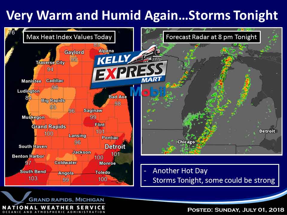
The National Weather Service has continued an Excessive Heat Warning in effect through 8 PM EDT tonight.  HAZARDOUS WEATHER:  Heat index values approaching 100 Sunday afternoon. Hot and humid weather will continue today, although temperatures and index values will be slightly less oppressive than they were Saturday. Showers and thunderstorms are possible today and tonight. Some of these storms could become severe with damaging winds and could produce local nuisance flooding. After a slightly cooler Monday, hot and humid conditions return with an increased chance for showers and thunderstorms on the 4th of July and again towards the end of the week. Saturday Mostly sunny and hot, with a high near 90. Heat index values as high as 96. South southwest wind 6 to 11 mph. Tonight A 40 percent chance of showers and thunderstorms, mainly before 4am. Mostly cloudy, with a low around 71. South southwest wind 7 to 9 mph. Monday A 30 percent chance of showers and thunderstorms, mainly after 8am. Partly sunny, with a high near 86. West wind around 7 mph. Monday Night Partly cloudy, with a low around 68. North northwest wind around 5 mph becoming calm in the evening. Tuesday A 30 percent…

Read more

Excessive Heat Warning with Hot and Humid Conditions

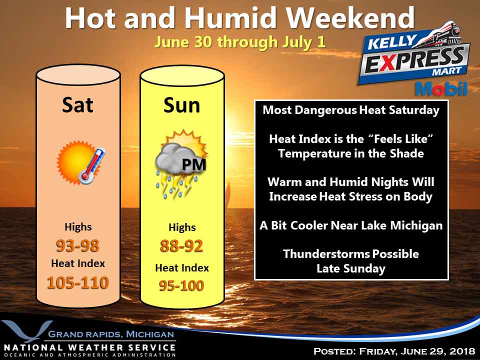
The National Weather Service has issued an Excessive Heat Warning in effect through 8 PM EDT Sunday.  HAZARDOUS WEATHER:  Heat indices approaching 110 Saturday afternoon, and around 100 Sunday afternoon. Hot and humid conditions will continue through the weekend. High temperatures will rise into the lower and middle 90s each afternoon...and low temperatures will only fall into the middle 70s...providing little relief. Shower and thunderstorm chances will increase late Sunday into early Monday as a cold front approaches the region. After a brief break in the heat...warmer temperatures will return by mid week. Saturday Sunny and hot, with a high near 93. Heat index values as high as 103. Southwest wind around 10 mph. Saturday Night Mostly clear, with a low around 73. South southwest wind around 7 mph. Sunday A 20 percent chance of showers and thunderstorms after 2pm. Mostly sunny and hot, with a high near 91. Heat index values as high as 99. South southwest wind 7 to 14 mph, with gusts as high as 23 mph. Sunday Night A 40 percent chance of showers and thunderstorms, mainly after 8pm. Mostly cloudy, with a low around 73. South southwest wind 8 to 10 mph. Monday A 40…

Read more

Hot and Humid with Excessive Heat Warning in Effect

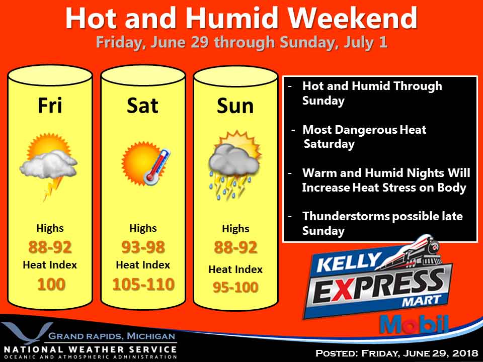
The National Weather Service has issued an Excessive Heat Warning in effect from noon today to 8 PM EDT Sunday.  HAZARDOUS WEATHER:  Heat indices around 100 this afternoon, approaching 110 Saturday afternoon, and around 100 Sunday afternoon. Today through Sunday afternoon will be very hot and humid.  Saturday and Sunday mornings will be very warm and humid with lows only making it down into the mid 70s. This continuous stretch of heat and humidity is expected to be interrupted late in the day Sunday with a chance for thunderstorms. Some storms could be severe with heavy rain. Most of the coming week will remain hot with highs frequently around 90. Today Sunny, with a high near 89. Calm wind becoming south 5 to 9 mph in the morning. Tonight Mostly clear, with a low around 73. South wind 7 to 9 mph. Saturday Sunny and hot, with a high near 94. Heat index values as high as 105. Southwest wind 8 to 10 mph. Saturday Night Mostly clear, with a low around 73. South southwest wind 5 to 8 mph. Sunday A slight chance of showers between 2pm and 5pm, then a slight chance of showers and thunderstorms after 5pm…

Read more

Contact Us

152 West Michigan Avenue
Jackson, MI 49201
517-787-8817
viewermail@jtv.tv

Back To Top