A FLOOD WATCH IS IN EFFECT FROM MONDAY AFTERNOON THROUGH WEDNESDAY AFTERNOON. The National Weather Service in Grand Rapids has issued a Flood Watch for portions of central Michigan, south central Michigan, southwest Michigan, and west central Michigan including Jackson County. The Flood Watch is in effect from Monday afternoon through Wednesday afternoon. 1 to 3 inches of rain is expected from Monday through Wednesday morning. Locally higher amounts are likely. The rainfall, combined with a melting snowpack and a frozen ground could cause flooding across the area.
Mainstem rivers and streams are already high, and will be rising more and could begin to flood areas around them. Ice jams resulting from the breakup of ice currently on the rivers will also be possible.
An area of high pressure centered over Missouri this morning will track up the Ohio Valley today. This fair weather system will provide the region with mainly dry weather and close to normal temperatures. Later tonight the southerly flow strengthens around the backside of this departing high pressure system. As a result some precipitation will start moving in. A brief period of mixed precipitation will be possible at the onset…but it is forecasted to transition quickly to rain showers for most of Monday.
Today
Mostly sunny, with a high near 40. West wind 6 to 13 mph becoming south in the afternoon. Winds could gust as high as 22 mph.
Tonight
A chance of rain and snow showers between 1am and 2am, then a chance of rain showers after 2am. Partly cloudy, with a steady temperature around 37. South southeast wind 11 to 17 mph, with gusts as high as 30 mph. Chance of precipitation is 30%.
Washington’s Birthday
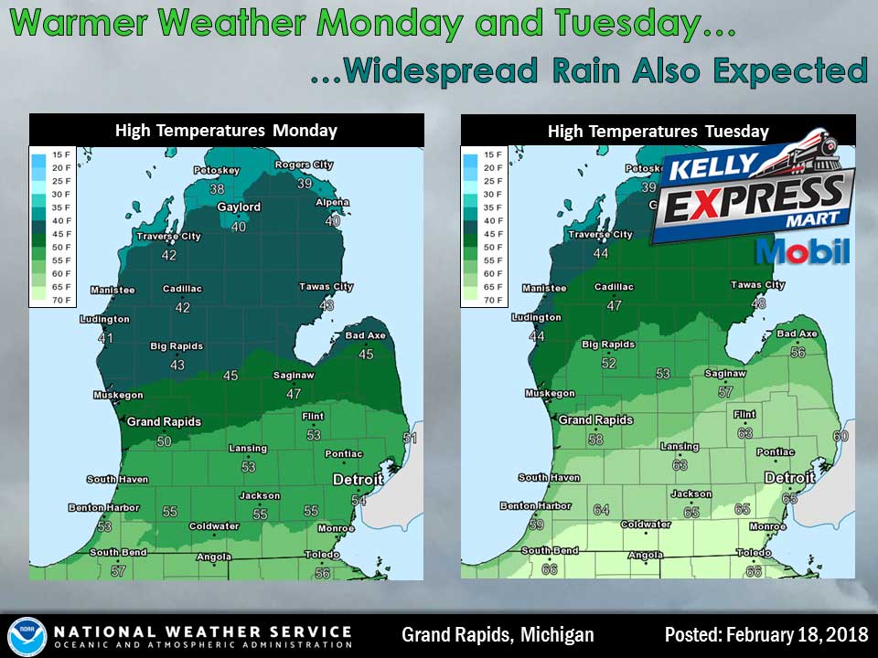
Showers likely, then showers and possibly a thunderstorm after 1pm. High near 55. South wind 7 to 10 mph. Chance of precipitation is 90%. New rainfall amounts between a tenth and quarter of an inch, except higher amounts possible in thunderstorms.
Monday Night
Showers and possibly a thunderstorm. Low around 52. South southwest wind around 14 mph, with gusts as high as 26 mph. Chance of precipitation is 90%. New rainfall amounts between a half and three quarters of an inch possible.
Tuesday
Showers and possibly a thunderstorm. High near 65. South southwest wind around 16 mph, with gusts as high as 26 mph. Chance of precipitation is 90%.
Tuesday Night
Showers and possibly a thunderstorm. Low around 38. Chance of precipitation is 90%.
Wednesday
A chance of rain and snow showers before 1pm. Mostly cloudy, with a high near 44. Chance of precipitation is 40%.
Wednesday Night
A slight chance of snow showers after 1am. Mostly cloudy, with a low around 25.
Thursday
Partly sunny, with a high near 38.
Average high temperature for today is 35. Average low temperature is 19.
The high temperature in Jackson yesterday was 34 at 4:59 PM, the low was 17 at 3:11 AM.
A trace of precipitation yesterday. Total precipitation for the month to date: 0.82 inches.
Sunrise today at 7:30 AM EST. Sunset at 6:14 PM EST.