Quantcast
skip to Main Content

Consumers Energy Battles Hazardous Winds, Bitter Cold to Restore Customers’ Power

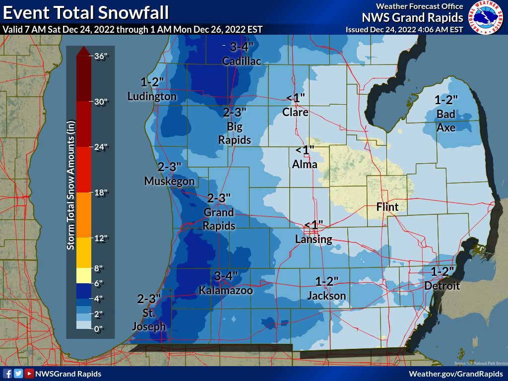
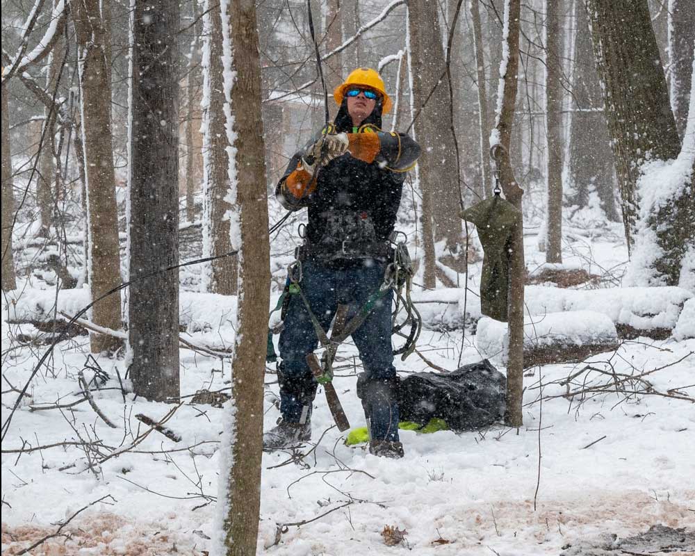
(January 14, 2024 11:32 AM ET) Consumers Energy lineworkers and contractors from as far away as New Brunswick, Canada braved high winds, lake effect snow and treacherous road conditions overnight Saturday to restore power to thousands of customers affected by a winter storm that struck the state Jan. 12. The hazardous winter weather downed tree limbs and more than 2,500 power lines across several regions. More than 500 crews – including out-of-state contractors – worked around the clock to reduce the number of customers from over 170,000 without power to about 25,000 as of 9 a.m. Sunday, despite constant widespread wind gusts that made line work challenging and caused more outages. The crews are supported by a team of over 150 dedicated storm restoration staff and volunteers across the state who are committed to enabling crews to restore heat and light to the people of Michigan. “Safety for our co-workers and our customers remains our top priority as we work to restore power as quickly and safely as possible,” said Melissa Gleespen, one of Consumers Energy’s Officers in Charge of restoration. “Despite bitter cold and high winds, crews continue to make significant progress, and our aim is to have the…

Read more

Burst of Winter Weather Today

(December 18, 2023 7:22 AM ET) Strong winds and the chance of rain and snow showers are forecast for the Jackson area today. Temperature rising to near 33 by mid morning, then falling to around 29 during the remainder of the day. Breezy, conditions, with a northwest wind 14 to 23 mph, with gusts as high as 37 mph are likely. Total daytime snow accumulation of less than one inch is possible. Lake effect snow is expected from this morning into tonight in West Michigan. Snowfall amounts will vary, but in general 2 to 6 inches of snow is expected west of Highway 131. Some isolated higher amounts are possible south of Saugatuck. Wind gusts of 40 to 50 mph near the lake will create areas of blowing snow. Be prepared for changeable travel conditions today. Consumers Energy last night said it is preparing for a storm that should bring wind gusts of up to 50 mph throughout the day Monday, creating the possibility of power outages. The Consumers Energy Storm Restoration Team has been monitoring this weather for several days. Over 180 crews are being staged in advance. The storm is expected to deliver the most serious impact along…

Read more

Winter Storm Warning Extended Through 7 PM this Evening

(December 24, 2022 7:34 AM) The National Weather Service has again extended the  WINTER STORM WARNING, now in effect until 7 PM this evening.   * WHAT...Light snow...blowing snow and hazardous travel conditions. Additional snow accumulations of 1 to locally 4 inches. Winds gusting as high as 40 mph. * WHERE...Eaton, Ingham, Calhoun and Jackson counties. * WHEN...Until 7 PM EST this evening. * IMPACTS...Plan on slippery road conditions. Widespread blowing snow will significantly reduce visibility to near zero at times. The cold wind chills as low as 25 below zero could cause frostbite on exposed skin in as little as 30 minutes. * ADDITIONAL DETAILS...Lake effect snow will continue to push inland and affect areas in the Winter Storm Warning. While snow totals will not be heavy, hazardous travel will continue with icy roads and areas of blowing snow. PRECAUTIONARY/PREPAREDNESS ACTIONS... If you must travel, keep an extra flashlight, food, and water in your vehicle in case of an emergency.

Read more

Winter Storm Warning Extended to 7 AM Saturday

(December 23, 2022 4:23 PM) The WINTER STORM WARNING now in effect has been extended to 7 AM EST Saturday. * WHAT...Whiteout conditions expected at times due to falling and blowing snow. Total snow accumulations of 4 to 8 inches by Sunday morning. Wind gusts as high as 50 mph. Wind chills to 15 below are expected. * WHERE...Portions of central and south central Michigan. * WHEN...Until 7 AM EST Saturday. * IMPACTS...Travel remains very difficult. Widespread blowing snow is significantly reducing visibility. Gusty winds could bring down tree branches. * ADDITIONAL DETAILS...Wind driven lake effect snow showers will continue through Saturday as well as drifting snow and cold temperatures. Snowfall totals across the warning area will range from 4 to 8 inches. The main component to this event will be the wind. Winds gusting in excess of 40 mph will create occasional whiteout conditions. The changeable weather will make for treacherous travel. The worst of the conditions are expected later this morning through Saturday. Wind chills of 10 to 20 below will make the danger of frost bite very real. PRECAUTIONARY/PREPAREDNESS ACTIONS... If you must travel, keep an extra flashlight, food, and water in your vehicle in case of…

Read more

Winter Storm Warning Begins at 4 PM Today

(December 22,2022 7:21 AM)  The Winter Storm Warning remains in effect from 4 PM today through 1 AM Saturday. The National Weather Service says snow will develop Thursday afternoon and become heavy Thursday night. Lake effect snow kicks in by Friday morning. Blizzard conditions will develop late Thursday night and worsen on Friday. Widespread blowing and drifting snow is expected in all areas with the worst of conditions near and west of Highway 131. Snowfall totals by the time the event ends Saturday night into Sunday morning may exceed a foot in many areas in Western Lower Michigan and over a half a foot in middle sections of the state near Highway 127. Travel will deteriorate rapidly Thursday evening and become dangerous quickly. The worst of the conditions are expected Friday. Travel is not advised. Details of the Winter Storm Warning: * WHAT...Heavy snow expected. Total snow accumulations of 6 to 10 inches. Winds gusting as high as 50 mph. * WHERE...Portions of central and south central Michigan. * WHEN...From 4 PM Thursday to 1 AM EST Saturday. * IMPACTS...Travel could be very difficult. Widespread blowing snow could significantly reduce visibility. The hazardous conditions could impact the morning or evening…

Read more

Gov. Whitmer Announces State-Local Preparedness Ahead of Winter Storm

(December 21, 2022 7:25 PM) Ahead of heavy snow, strong winds, and dangerously cold temperatures forecasted later this week, Governor Gretchen Whitmer announced the coordination of preparedness efforts between the State of Michigan and local communities to ensure full staffing of first responders, pre-deployment of utility repair crews, readiness for road crews, and availability of warming shelters. The governor also highlighted resources and tips to help Michiganders stay safe.   “With potentially dangerous winter weather on the way, it is important to prepare and be ready ahead of time to keep yourself, your family, and your neighbors safe,” said Governor Whitmer. “The State of Michigan is closely watching conditions as they develop and taking action to prepare for winter weather impacts. We will continue working hard to protect the health and safety of Michiganders, and are grateful for the dedicated first responders working to keep Michiganders safe this weekend.”  Travel is expected to be dangerous statewide Thursday through Saturday. The National Weather Service is forecasting the potential for blizzard conditions in the Upper Peninsula starting Thursday, and in the Lower Peninsula starting on Friday. Blizzard conditions are expected to last through Saturday with wind gusts between 40-50 mph and gusts…

Read more

Consumers Energy Preparing for Hazardous Winter Storm

Consumers Energy CEO Garrick Rochow in a video message to customers. See video below. (December 21, 2022 3:58 PM) Consumers Energy is preparing for a large winter storm that is expected to hit the Great Lakes region with heavy snow, freezing temperatures, and damaging wind gusts that could affect Michigan later this week and into the weekend. This storm system is forecasted to begin late Thursday night and continue into Saturday. It could include winds over 60 mph, resulting in power outages, downed wires and other safety hazards. “Consumers Energy customers should know we are all-hands-on-deck preparing for this storm. Crews are preparing trucks and essential materials right now to assist with any restoration efforts,” said Garrick Rochow, President and CEO of Consumers Energy. “We are ready and we’ll work as quickly and as safely as possible to restore any outages this storm may cause. We are grateful for our customers’ patience and understanding.” The National Weather Service has issued a Winter Storm Warning for Jackson County, along with central and southern lower Michigan.  Blizzard Warnings have been issued for counties in western Michigan.  Dangerous weather conditions are expected to begin late afternoon Thursday and last into Saturday. To help…

Read more

UPDATED: Winter Storm Warning Issued

(UPDATED December 21, 2022 11:50 AM) The National Weather Service in Grand Rapids has issued a WINTER STORM WARNING in effect from Thursday afternoon through Saturday morning for Jackson County and Central and Southern Lower Michigan. The Weather Service has issued a BLIZZARD WARNING for the West Michigan counties along the Lake Michigan coast. The NWS says a major winter storm will emerge into the Plains from the Rockies on Wednesday night and rapidly move into the Great Lakes on Thursday. Widespread snow is expected to develop Thursday afternoon and evening. Heavy snow will occur Thursday night and continue into Friday. A surge of wind will be added to the mix on Friday and Friday night with gusts over 40 mph likely and over 50 mph very possible. Heavy snow and winds of that magnitude set the stage for the potential of blizzard conditions. The worst of the weather should be Friday and Friday night as snow and blowing snow create whiteout/blizzard conditions. You are urged to complete travel on Thursday as conditions on Friday are expected to be treacherous to life threatening at times.  This afternoon, the NWS upgraded the WATCH to a WARNING with these details: * WHAT...Heavy…

Read more

Severe Weather Possible Late This Afternoon and Tonight

(June 13, 2022 11:18 AM) A portion of Southern Lower Michigan could see a swath of damaging winds resulting in fallen trees and scattered to numerous power outages Monday afternoon or evening. Fast moving storms are expected to cross Lake Michigan during this time. Consumers Energy announced this morning they are preparing for damaging straight-line winds and severe thunderstorms that are expected to hit the lower regions of the lower peninsula starting Monday afternoon through late Monday night. Some of these storms may include heavy rain, hail and winds near 70 mph, resulting in power outages, downed wires and other safety hazards. The National Weather Service says there is a potential of some significant severe weather later this afternoon and evening across southern lower Michigan. The main time of concern will be from 4 pm this afternoon until about 2 am Tuesday morning. Damaging winds of 60 mph will be the main threat, with some significant winds of over 75 mph possible. There are lower chances of hail and a tornado. There is a chance also that some localized flooding could occur where storms would train over the same area for longer periods.  If you are outdoors, have a plan…

Read more
Back To Top
Search