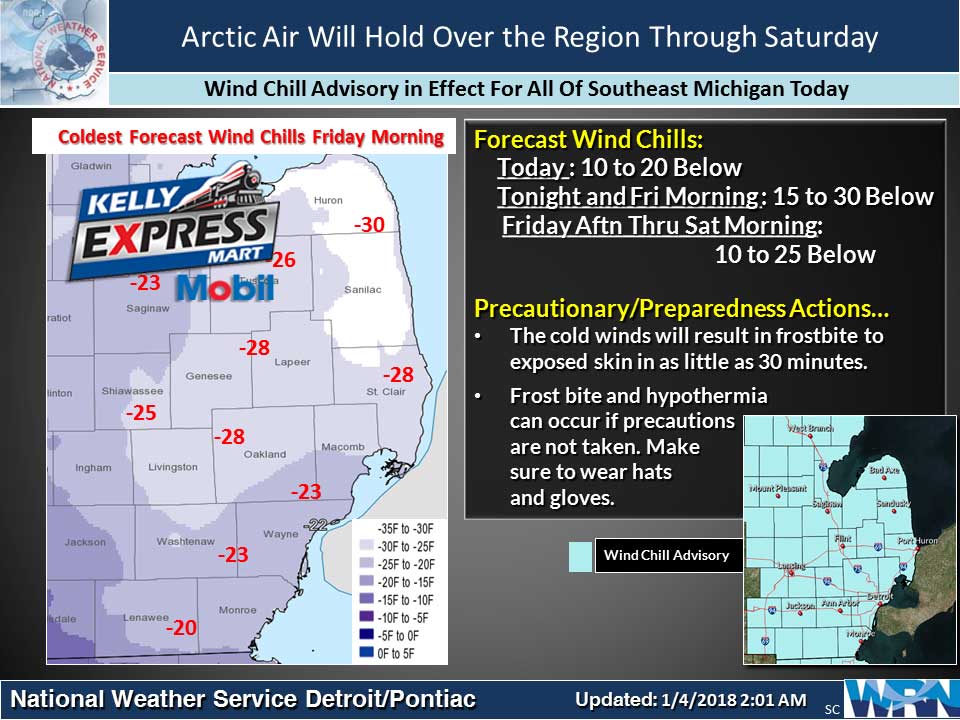
WIND CHILL ADVISORY REMAINS IN EFFECT UNTIL 12 NOON EST TODAY. Very cold wind chills expected. The cold wind chills will cause frostbite in as little as 30 minutes to exposed skin. Expect wind chills to range from 10 below zero to 20 below zero.
Cold temperatures with wind chill values near -15 degrees this morning and closer to -20 degrees tomorrow morning. Little of any snow is expected. It also seems we will see some snow Sunday and a significant warm up Sunday into Monday before another arctic cold front brings more cold air back to the area.
Today
Mostly sunny and cold, with a high near 10. Wind chill values as low as -15. Northwest wind 9 to 16 mph.
Tonight
Increasing clouds, with a low around -1. Wind chill values as low as -17. Northwest wind 9 to 14 mph becoming light after midnight.
Friday
Partly sunny, then gradually becoming sunny and cold, with a high near 8. Wind chill values as low as -16. North northwest wind 6 to 14 mph.
Friday Night
Mostly clear, with a low around -7. Wind chill values as low as -15. West northwest wind 5 to 9 mph.
Saturday
Mostly sunny and cold, with a high near 10. Calm wind becoming west around 6 mph in the afternoon.
Saturday Night
Mostly cloudy, with a low around 1.
Sunday
Snow likely, mainly after 2pm. Cloudy, with a high near 28. Chance of precipitation is 60%.
Sunday Night
Snow likely. Cloudy, with a low around 24.
Monday
Snow likely, mainly before 8am, then a chance of snow showers after 2pm. Cloudy, with a high near 35.
Monday Night
A chance of snow showers, mainly before 8pm. Mostly cloudy, with a low around 20.
Tuesday
Partly sunny, with a high near 27.
Average high temperature for today is 31. Average low temperature is 17.
The high temperature in Jackson yesterday was 16 at 11:58 PM, the low was 2 at 12:03 AM.
A trace of precipitation yesterday. Total precipitation for the month to date: Trace. Since December 1: 0.68 inches.
Sunrise today at 8:07 AM EST. Sunset at 5:19 PM EST.