Quantcast
Skip to content

Sunny and Warm for Monday and Tuesday

High pressure will move east with southwest winds bringing in warmer temperatures today and Tuesday. A cold front will stall across Lower Michigan bringing showers and thunderstorms Tuesday night and continuing into Friday. Today:  Sunny, with a high near 68. West southwest wind 5 to 13 mph, with gusts as high as 21 mph. Tonight Clear, with a low around 50. South southwest wind 8 to 13 mph. Tuesday Sunny, with a high near 79. Southwest wind 11 to 15 mph, with gusts as high as 25 mph. Tuesday Night A 20 percent chance of rain and thunderstorms after 2am. Partly cloudy, with a low around 58. South southwest wind around 14 mph, with gusts as high as 22 mph. Wednesday A 30 percent chance of rain and thunderstorms, mainly after 2pm. Mostly cloudy, with a high near 77. Southwest wind 13 to 17 mph, with gusts as high as 29 mph. Wednesday Night A chance of rain and thunderstorms before 8pm, then showers likely and possibly a thunderstorm between 8pm and 2am, then a chance of showers and thunderstorms after 2am. Mostly cloudy, with a low around 61. Chance of precipitation is 60%. Thursday A chance of showers and…


Read more

Sunny with a High of Upper 50s

High pressure will bring fair and cool weather today and tonight but temperatures will be warming on Monday and Tuesday as the high moves east. A front will push into Michigan by Wednesday with rain expected through Thursday as low pressure moves along the front. Today:  Sunny, with a high near 58. North northwest wind 7 to 9 mph. Tonight Mostly clear, with a low around 33. West northwest wind around 6 mph. Monday Sunny, with a high near 69. West southwest wind 6 to 13 mph, with gusts as high as 22 mph. Monday Night Partly cloudy, with a low around 48. South southwest wind around 9 mph. Tuesday Sunny, with a high near 77. Southwest wind 10 to 17 mph, with gusts as high as 26 mph. Tuesday Night A 20 percent chance of showers and thunderstorms after 2am. Mostly cloudy, with a low around 58. Wednesday A 40 percent chance of showers and thunderstorms, mainly after 8am. Mostly cloudy, with a high near 74. Wednesday Night Showers and thunderstorms likely, mainly before 2am. Cloudy, with a low around 58. Thursday A chance of showers and thunderstorms. Cloudy, with a high near 74. Thursday Night Showers and thunderstorms…

Read more

Breezy and Cooler

High pressure will bring fair weather through early next week. Cold temperatures this weekend will moderate early next week. Showers and thunderstorms by Tuesday night and Wednesday. Today:  Cloudy, then gradually becoming mostly sunny, with a high near 52. North northwest wind 8 to 17 mph, with gusts as high as 26 mph. Tonight Mostly clear, with a low around 26. North northwest wind 8 to 11 mph. Sunday Sunny, with a high near 56. North northwest wind 9 to 13 mph, with gusts as high as 21 mph. Sunday Night Mostly clear, with a low around 34. West northwest wind around 7 mph. Monday Sunny, with a high near 68. Southwest wind 6 to 14 mph, with gusts as high as 23 mph. Monday Night Partly cloudy, with a low around 47. Tuesday Sunny, with a high near 74. Tuesday Night A slight chance of showers after 2am. Partly cloudy, with a low around 55. Wednesday A chance of showers, with thunderstorms also possible after 2pm. Mostly cloudy, with a high near 72. Wednesday Night A chance of showers and thunderstorms, then showers likely and possibly a thunderstorm after 2am. Cloudy, with a low around 57. Thursday Showers and…

Read more

Chance of Showers Today, Cooler Weekend

A cold front will bring a chance of showers today then a clipper will track just south of Lower Michigan tonight bringing rain and even a mix with snow. Fair and cool weather will follow for Saturday and Sunday. Today:  A chance of rain between 8am and 2pm. Partly sunny, with a high near 61. Light southwest wind becoming west southwest 5 to 10 mph in the morning. Winds could gust as high as 18 mph. Chance of precipitation is 40%. Tonight Rain likely before 3am, then a chance of rain and snow between 3am and 5am, then a chance of snow after 5am. Cloudy, with a low around 34. North northwest wind 9 to 15 mph. Chance of precipitation is 60%. Little or no snow accumulation expected. Saturday A chance of snow before 9am, then a slight chance of rain showers between 9am and 2pm. Mostly cloudy, with a high near 48. Northwest wind 11 to 15 mph, with gusts as high as 25 mph. Chance of precipitation is 30%. Saturday Night Mostly cloudy, then gradually becoming clear, with a low around 27. North northwest wind 6 to 9 mph. Sunday Sunny, with a high near 55. Northwest wind…

Read more

Sunny and Pleasant

High pressure will provide sunny and pleasant weather today before a cold front on Friday ushers in chilly weather for the weekend. Highs on Saturday will struggle to reach 50 degrees. The cold snap will be short lived however and above normal temperatures in the 70s are expected for much of next week. Today:  Sunny, with a high near 64. Calm wind becoming west southwest around 5 mph in the afternoon. Tonight Partly cloudy, with a low around 40. Light south southwest wind. Friday A 30 percent chance of showers before 2pm. Partly sunny, with a high near 57. West northwest wind 5 to 9 mph. Friday Night A chance of rain showers after 8pm, mixing with snow after 5am. Mostly cloudy, with a low around 35. North northwest wind 5 to 8 mph. Chance of precipitation is 50%. Saturday A 30 percent chance of snow showers before 8am. Partly sunny, with a high near 49. North northwest wind 9 to 13 mph, with gusts as high as 22 mph. Saturday Night Mostly clear, with a low around 28. Sunday Sunny, with a high near 55. Sunday Night Clear, with a low around 35. Monday Sunny, with a high near…

Read more

Partly Sunny and Breezy

The passage of a cold front this morning will end the threat of showers and be followed by breezy and cool conditions today. High pressure will provide a sunny and pleasant day Thursday with lighter winds before another cold front on Friday brings our next chance of showers. Cool weather with highs in the 50s will prevail behind this front over the weekend, but a significant warm up with highs in the 70s will follow for early next week. Today:  Partly sunny, with a high near 57. North wind 11 to 15 mph, with gusts as high as 23 mph. Tonight Mostly cloudy, then gradually becoming clear, with a low around 34. North wind 5 to 7 mph becoming calm in the evening. Thursday Sunny, with a high near 61. Calm wind becoming west northwest around 6 mph in the morning. Thursday Night Mostly clear, with a low around 39. West wind around 5 mph becoming calm in the evening. Friday A 20 percent chance of showers before 2pm. Partly sunny, with a high near 56. West northwest wind 5 to 11 mph. Friday Night A chance of showers between 8pm and 2am. Partly cloudy, with a low around 35…

Read more

Chance of Showers

Cooler temperatures can be expected the rest of the week, although highs will still be near to only slightly below normal.  Weak low pressure over the Ohio Valley and a cold front approaching from the northwest will bring clouds and scattered showers today and tonight. High pressure will build back into the region on Wednesday resulting in decreasing clouds and dry weather which continues into Thursday. Today:  A 50 percent chance of showers. Cloudy, with a high near 57. East southeast wind 7 to 10 mph. Tonight A 50 percent chance of showers. Cloudy, with a low around 42. Calm wind becoming north around 6 mph after midnight. Wednesday Partly sunny, with a high near 53. North northwest wind 11 to 15 mph, with gusts as high as 24 mph. Wednesday Night Mostly clear, with a low around 33. North wind 5 to 9 mph becoming light north northwest in the evening. Thursday Sunny, with a high near 60. West northwest wind 3 to 6 mph. Thursday Night Partly cloudy, with a low around 39. Friday A 40 percent chance of showers. Mostly cloudy, with a high near 57. Friday Night Partly cloudy, with a low around 35. Saturday Mostly…

Read more

Mostly Sunny and Mild

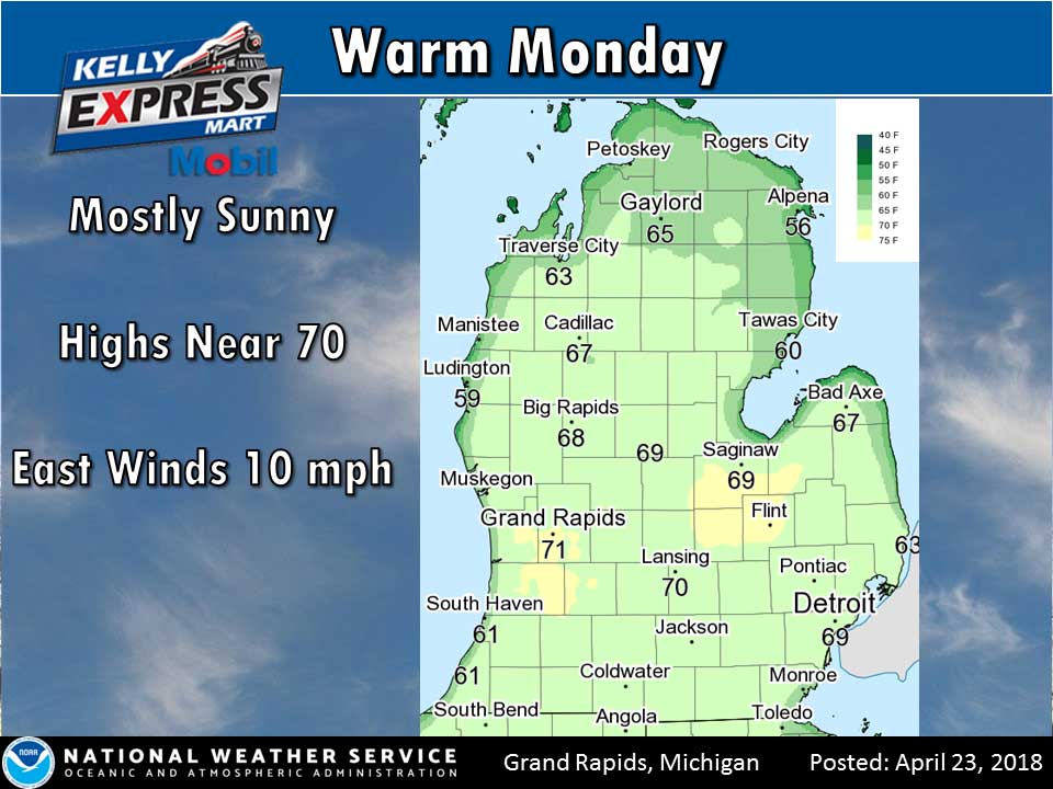
High pressure will provide another mostly sunny and mild day with high temperatures near 70. A slow moving low pressure system tracking south of Michigan will bring clouds and scattered light rain showers for Tuesday. After today cooler temperatures, generally in the 50s, will prevail through the rest of the week. Today:  Sunny, with a high near 69. East southeast wind 6 to 10 mph. Tonight A 30 percent chance of showers, mainly after 2am. Mostly cloudy, with a low around 47. East southeast wind 8 to 11 mph. Tuesday A 50 percent chance of showers. Cloudy, with a high near 57. East southeast wind around 9 mph. Tuesday Night A 50 percent chance of showers. Cloudy, with a low around 42. East wind 5 to 7 mph becoming north after midnight. Wednesday Partly sunny, with a high near 53. North wind 10 to 14 mph. Wednesday Night Partly cloudy, with a low around 34. Thursday Sunny, with a high near 58. Thursday Night Partly cloudy, with a low around 39. Friday A chance of showers. Mostly cloudy, with a high near 55. Friday Night Partly cloudy, with a low around 33. Saturday Mostly sunny, with a high near 56…

Read more

Sunny and Warmer

High pressure will provide mostly sunny and mild weather, with the possibility of our first 70 degree reading of the season on Monday. Low pressure tracking south of Michigan on Tuesday will bring clouds and a chance of light rain, followed by slightly cooler weather for midweek. Today:  Sunny, with a high near 64. Light east wind increasing to 6 to 11 mph in the morning. Tonight Clear, with a low around 34. East wind 7 to 9 mph. Monday Sunny, with a high near 67. East wind 8 to 11 mph. Monday Night A 30 percent chance of showers, mainly after 2am. Mostly cloudy, with a low around 46. Southeast wind 7 to 9 mph. Tuesday A 40 percent chance of showers. Cloudy, with a high near 57. East wind 7 to 9 mph. Tuesday Night A 30 percent chance of showers, mainly before 2am. Cloudy, with a low around 40. Wednesday A 10 percent chance of showers before 8am. Partly sunny, with a high near 54. Wednesday Night Partly cloudy, with a low around 34. Thursday Mostly sunny, with a high near 58. Thursday Night A chance of showers before 2am. Mostly cloudy, with a low around 39…

Read more

Dry and Warmer Weekend

Dry weather is forecast through Monday night courtesy of an area of high pressure that will be anchored across the Great Lakes region. Some cloud cover today will keep high temperatures a bit lower than what would be achieved under sunny skies, but we are still expecting upper 50s once again today. Highs will push into the low 60s on Sunday and rise into the upper 60s on Monday. Most of this month has seen temperatures average below normal, so for those looking for spring they will enjoy Sunday and Monday. Today:  Mostly cloudy, with a high near 57. South wind 5 to 7 mph. Tonight Mostly cloudy, then gradually becoming mostly clear, with a low around 35. Light south southeast wind. Sunday Sunny, with a high near 60. Light east southeast wind becoming east 5 to 10 mph in the morning. Sunday Night Mostly clear, with a low around 36. East wind 6 to 8 mph. Monday Sunny, with a high near 65. Southeast wind 8 to 10 mph. Monday Night Partly cloudy, with a low around 43. Tuesday A 30 percent chance of showers, mainly after 2pm. Mostly cloudy, with a high near 60. Tuesday Night A chance…

Read more

Contact Us

152 West Michigan Avenue
Jackson, MI 49201
517-787-8817
viewermail@jtv.tv

Back To Top