Quantcast
Skip to content

A Nice Weekend

Clear to partly cloudy skies can be expected through the weekend with dry weather forecast. High pressure will slowly drift through the area into early next week ensuring a precipitation free forecast. Temperatures will continue to moderate for those folks looking for spring. Temperatures will reach the upper 50s today and hit the lower 60s over the weekend. Even warmer temperatures are anticipated early next week when mid to upper 60s readings are forecast. Today Sunny, with a high near 57. North wind 5 to 9 mph. Tonight Mostly clear, with a low around 32. North wind around 5 mph becoming calm in the evening. Saturday Partly sunny, with a high near 58. Calm wind. Saturday Night Partly cloudy, with a low around 36. Calm wind becoming southeast 5 to 7 mph. Sunday Sunny, with a high near 59. Light east wind increasing to 5 to 10 mph in the morning. Sunday Night Mostly clear, with a low around 36. Monday Mostly sunny, with a high near 65. Monday Night Partly cloudy, with a low around 41. Tuesday A slight chance of showers after 2pm. Mostly cloudy, with a high near 62. Tuesday Night A chance of showers, mainly after…

Read more

Mostly Cloudy and Breezy

A slow moving area of high pressure will drift into the Great Lakes region today and tonight. The high will remain over our area through the weekend. The high will bring dry and quiet conditions. Mainly clear skies are expected the next several days. The next chance of precipitation comes Tuesday night into Wednesday of next week so we are looking at a prolonged period of dry weather. We are forecasting a moderating trend in temperatures the next few days. Highs today will top out in the 40s, warming the 50s for Friday and Saturday and reaching near 60 on Sunday. Normal highs for this time of year are in the upper 50s to around 60 degree Today Mostly cloudy, then gradually becoming sunny, with a high near 46. North northwest wind 9 to 15 mph, with gusts as high as 24 mph. Tonight Mostly clear, with a low around 27. Northwest wind 6 to 13 mph. Friday Sunny, with a high near 52. North northwest wind 5 to 10 mph. Friday Night Mostly clear, with a low around 32. Light and variable wind becoming west northwest around 5 mph. Saturday Partly sunny, with a high near 56. Light and…

Read more

Mostly Cloudy, Rain & Snow Developing Tonight

Low pressure will move from Missouri this morning to Pennsylvania by Thursday morning. As the low moves south of the Great Lakes precipitation will spread into Lower Michigan this afternoon and continue into Tonight. The precipitation will start off as mainly rain this afternoon as temperatures warm into the 40s. Tonight however, readings will cool into the 30s and the precipitation will switch over to snow. Light accumulations of snow are certainly possible with a dusting to possibly around 1 inch of new snow forecast in many areas. Dry weather will return for Thursday and continue right through the upcoming weekend as high pressure settles into the Great Lakes region. After highs in the 40s today and Thursday, readings will warm into the 50s on Friday, possibly hitting 60 over the weekend. Today A 20 percent chance of rain after 2pm. Mostly cloudy, with a high near 47. Calm wind becoming east southeast 5 to 9 mph in the afternoon. Tonight Rain and snow, becoming all snow after midnight. Low around 30. East wind 7 to 15 mph becoming north after midnight. Chance of precipitation is 90%. New snow accumulation of less than one inch possible. Thursday A 30 percent…

Read more

Snow Showers and Windy

Snow showers will diminish through the day as high pressure moves over the region by late in the day. We will see one last day today of much below average temperatures with highs only in the 30s once again.  After a break tonight and early Wednesday, rain will spread over the region Wednesday afternoon as the next system moves through the region. Rain will turn to snow Wednesday evening, with some accumulations of an inch or so possible mainly on grassy areas. Snow will come to an end Thursday morning.  Much quieter weather is then expected to move in later Thursday, and hold over the area through the weekend and into early next week. Temperatures will warm up, with 60 likely this weekend, and warmer temperatures possible early next week. Today A 50 percent chance of snow showers, mainly before noon. Cloudy, with a high near 39. West northwest wind 15 to 18 mph, with gusts as high as 28 mph. Tuesday Night Partly cloudy, with a low around 26. West northwest wind 6 to 13 mph. Wednesday Showers and possibly a thunderstorm after 2pm. High near 48. Light and variable wind becoming southeast 5 to 7 mph in the…

Read more

Snow Showers

Our slow moving storm system has moved to our east so now we are in the cold wrap around phase of the system. This means snow showers into Tuesday morning. Briefly A high pressure system moves across the area later Tuesday into Wednesday but that is quickly followed by yet another storm for later Wednesday into Thursday. This will be a rain to snow event. Temperatures will run about 10 to 20 degrees below normal through Thursday. Then a warm up begins late in the week and continues into the weekend. Today Rain and snow showers likely before 2pm, then a chance of drizzle between 2pm and 4pm, then a chance of rain and snow showers after 4pm. Patchy fog before 11am, then patchy fog after 4pm. Otherwise, cloudy, with a high near 37. West wind 10 to 18 mph, with gusts as high as 26 mph. Chance of precipitation is 60%. Total daytime snow accumulation of less than a half inch possible. Tonight Snow showers likely, mainly between 8pm and 11pm. Patchy fog before 9pm. Otherwise, cloudy, with a low around 27. West wind 13 to 17 mph, with gusts as high as 26 mph. Chance of precipitation is…

Read more

Winter Weather Advisory Until 12 Noon

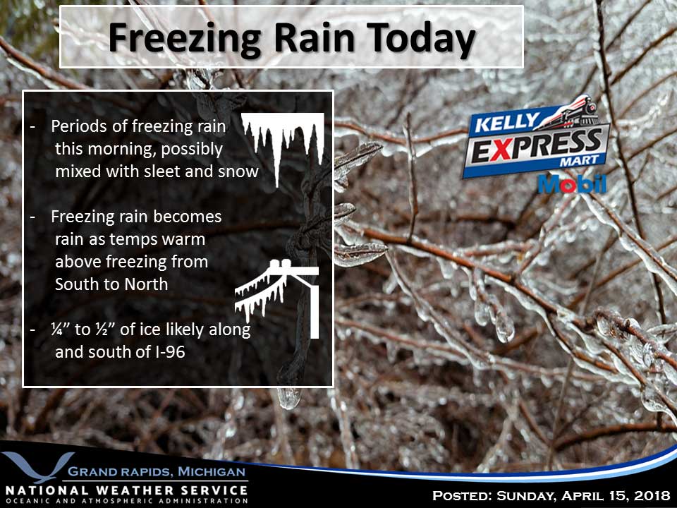
A WINTER WEATHER ADVISORY REMAINS IN EFFECT UNTIL NOON EDT TODAY.   The early spring storm will continue into today as a slow moving storm, centered to our south continues to slowly move east. Significant accumulations of ice and sleet are expected this morning before temperatures warm enough to change the freezing rain to rain near and south of I-96. I will remain windy into this afternoon and temperatures will remain cold through most of this coming week. The precipitation should become all snow tonight and continue into Tuesday morning. Accumulations will be limited. Today Showers. High near 42. East wind 9 to 18 mph, with gusts as high as 32 mph. Chance of precipitation is 100%. New precipitation amounts between a half and three quarters of an inch possible. Tonight Rain showers likely before 3am, then a chance of rain and snow showers. Cloudy, with a low around 34. West southwest wind 5 to 10 mph. Chance of precipitation is 60%. Little or no snow accumulation expected. Monday A chance of snow showers before 10am, then a chance of rain and snow showers between 10am and 1pm, then a chance of rain showers after 1pm. Cloudy, with a high…

Read more

Winter Weather Advisory Beginning at 5 PM Today

A WINTER WEATHER ADVISORY REMAINS IN EFFECT FROM 5 PM THIS AFTERNOON TO NOON EDT SUNDAY.  A major winter storm will continue to impact this area into Sunday. Today rain will change to freezing rain and sleet near and north of I-96 with some thunderstorms possible today into this evening. Gusty winds will increase the impacts of ice accumulations today into Sunday morning. The area of ice accumulations will spread south to the I-94 corridor tonight. Some slightly warmer air moves into the area Sunday afternoon but colder air follows Sunday night into Monday changing the rain, freezing rain and sleet to snow. Some accumulations are possible. Today Showers and possibly a thunderstorm. Some of the storms could produce heavy rainfall. Patchy fog between 9am and 10am. Temperature falling to around 36 by 4pm. Northeast wind 14 to 17 mph, with gusts as high as 34 mph. Chance of precipitation is 100%. New rainfall amounts between three quarters and one inch possible. Tonight A chance of rain showers before 9pm, then freezing rain. Some thunder is also possible. Low around 31. East wind 16 to 18 mph, with gusts as high as 36 mph. Chance of precipitation is 90%. New…

Read more

Some Showers and Thunderstorms

A Major early spring storm will bring showers and thunderstorms to the area today into tonight. A large area of freezing rain and some sleet is expected Saturday into Sunday. Some areas may see major impacts from the freezing rain Saturday into Sunday. Enough cold air wraps into the system Sunday evening to change the rain/freezing rain to snow but snowfall amounts at this point look limited. Today Friday A chance of showers, with thunderstorms also possible after 8am. Mostly cloudy, with a high near 59. East wind 8 to 13 mph becoming south in the afternoon. Chance of precipitation is 30%. Friday Night A chance of showers and thunderstorms, then showers and possibly a thunderstorm after 8pm. Patchy fog before 11pm. Low around 40. East northeast wind 9 to 13 mph. Chance of precipitation is 90%. New rainfall amounts between a quarter and half of an inch possible. Saturday Showers and possibly a thunderstorm. Patchy fog before 9am. High near 41. Breezy, with a northeast wind 16 to 21 mph, with gusts as high as 31 mph. Chance of precipitation is 100%. New rainfall amounts between three quarters and one inch possible. Saturday Night Rain showers before 2am, then…

Read more

Morning Showers and Warming Up

One area of rain will push eastward through the region early this  morning. Then the rest of the day should be dry as we will be between systems. A warm front lifts northward through the area tonight and Friday. Additional showers and perhaps a few thunderstorms are forecasted to accompany this feature. A major storm winds up in the Great Lakes region for the weekend leading to a prolong period of impactful weather. Today Showers, mainly before 11am. High near 65. Breezy, with a south wind 11 to 16 mph becoming west southwest 18 to 23 mph in the afternoon. Winds could gust as high as 38 mph. Chance of precipitation is 80%. New precipitation amounts of less than a tenth of an inch possible. Tonight A 30 percent chance of showers, mainly before 2am. Mostly cloudy, with a low around 46. Northwest wind 6 to 8 mph becoming east after midnight. Friday A 30 percent chance of showers and thunderstorms, mainly after 2pm. Mostly cloudy, with a high near 65. South southwest wind 8 to 11 mph. Friday Night A chance of showers and thunderstorms, then showers and possibly a thunderstorm after 2am. Low around 45. Southwest wind 7…

Read more

Early Showers Becoming Partly Sunny

A series of low pressure systems will track through the region over the next couple of days resulting in unsettled weather. Light precipitation this morning will end quickly leading to a dry day for the area. A fast moving low pressure system tracks through tonight with a round of rain. Then warm front lifts northward through the region for Friday causing more showers and moderating temperatures especially for southern Lower Michigan. Today A chance of rain and snow showers before 10am, then a slight chance of rain showers between 10am and 1pm. Mostly cloudy, with a high near 55. Breezy, with a south southwest wind 11 to 20 mph, with gusts as high as 33 mph. Chance of precipitation is 30%. Wednesday Night Showers, with thunderstorms also possible after 2am. Low around 44. Light and variable wind becoming south southeast 5 to 10 mph after midnight. Chance of precipitation is 90%. New rainfall amounts between a tenth and quarter of an inch, except higher amounts possible in thunderstorms. Thursday A slight chance of thunderstorms before 8am. Partly sunny, with a high near 63. Breezy, with a west wind 18 to 21 mph, with gusts as high as 37 mph. Chance…

Read more

Contact Us

152 West Michigan Avenue
Jackson, MI 49201
517-787-8817
viewermail@jtv.tv

Back To Top