Quantcast
Skip to content

A Cooler Sunday

Cool weather is expected today through Tuesday. Temperatures will likely stay in the 60s for highs both today and especially on Monday. We will warm slightly into the lower 70s for Tuesday.  Normal high temperatures for this time of year are in the lower 80s, so we will be well below normal. Scattered showers are expected today through Monday with an isolated thunderstorm possible as well. Any storms should mainly occur during the afternoon hours. Today:  Partly sunny. A 20 percent chance of showers and thunderstorms in the afternoon. Highs around 70. West winds 10 to 20 mph with gusts to around 30 mph. Tonight:  Partly cloudy. A 20 percent chance of rain showers overnight. Lows in the lower 50s. West winds 5 to 10 mph. Gusts up to 20 mph in the evening. Monday:  Partly sunny. A slight chance of rain showers until midday, then a chance of rain showers and a slight chance of thunderstorms in the afternoon. Highs in the upper 60s. West winds 15 to 20 mph with gusts to around 30 mph. Chance of rain 30 percent. Yesterday’s high temperature in Jackson was 76 at 2:22 PM.  The low was 57 at 11:59 PM. Normal…

Read more

Sunny, Cooler and Breezy

A cool airmass will gradually continue to filter into the Great Lakes region over the next few days. Highs today will reach the lower 70s, be near 70 on Sunday and top out in the middle to upper 60s on Monday. Normal highs are in the lower 80s this time of year so we are well below normal. Partly to occasionally mostly cloudy skies can be expected the next few days with isolated showers. Each afternoon a thunderstorm will be possible as well. Today:  Mostly sunny, with a high near 74. West wind 8 to 17 mph, with gusts as high as 28 mph. Tonight:  Partly cloudy, with a low around 53. West southwest wind 8 to 14 mph, with gusts as high as 22 mph. Sunday:  A slight chance of showers, with thunderstorms also possible after 2pm. Mostly sunny, with a high near 70. West wind 10 to 16 mph, with gusts as high as 26 mph. Chance of precipitation is 20%. Yesterday’s high temperature in Jackson was 78 at 11:22 AM.  The low was 63 at 11:20 PM. Normal high for today is 81.  The record low is 45, set in 1961.  The record high is 94, set…

Read more

Rainy Start, Drying Out this Afternoon

A cold front will push south through the area this morning bringing rounds of showers and thunderstorms. Cooler and less humid air will filter in behind the front this evening and tonight. Lows tonight will dip into the upper 50s with highs on Saturday only making it to around 70 degrees. The cooler conditions will persist into Sunday as well with highs around 70 once again. After a dry night tonight, small chances for showers and a scattered thunderstorm return to the forecast for the weekend. Today:  Showers and thunderstorms likely until midday, then partly sunny with a chance of showers and thunderstorms in the afternoon. Some thunderstorms may produce heavy rainfall until midday. Highs in the upper 70s. West winds 10 to 15 mph becoming northwest in the afternoon. Chance of rain 70 percent. Tonight:  Partly cloudy. Lows in the upper 50s. West winds 5 to 10 mph. Saturday:  Mostly sunny with a slight chance of rain showers until midday, then partly sunny with a chance of rain showers and a slight chance of thunderstorms in the afternoon. Highs in the upper 60s. West winds 10 to 15 mph with gusts to around 30 mph. Chance of rain 30…

Read more

Possible Showers and Thunderstorms

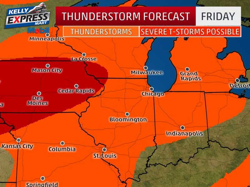
A cold front currently stretches from western Minnesota south to northeast Nebraska. A warm front stretched from central Wisconsin southeast to near Chicago. Thunderstorms were developing over Iowa and Wisconsin and moving toward Lower Michigan. The next 24-30 hours will be stormy until the cold front passes through the state Friday. Several days of cooler weather will follow with highs in the lower to mid 70s over the weekend. Today:  Mostly sunny until midday then becoming partly sunny. Scattered showers and thunderstorms. Highs in the mid 80s. Southwest winds 10 to 15 mph with gusts to around 30 mph. Chance of rain 40 percent. Tonight:  Scattered showers and thunderstorms in the evening, then numerous showers and thunderstorms overnight. Lows in the lower 70s. Southwest winds 10 to 15 mph with gusts to around 25 mph. Chance of rain 70 percent. Friday:  Numerous showers and thunderstorms until midday, then partly sunny with isolated showers and thunderstorms in the afternoon. Highs in the upper 70s. West winds 10 to 15 mph with gusts to around 25 mph. Chance of rain 60 percent. Saturday:  Mostly sunny. Highs in the lower 70s. West winds 10 to 15 mph with gusts to around 30 mph…

Read more

Sunny and Pleasant

We’ll have several opportunities for showers and thunderstorms during the next few days. Thunderstorms are expected late tonight and again Thursday night ahead of a cold front. Thursday will be the warmest day with highs in the mid 80s, and then a slow cooling trend will result in highs in the lower 70s by Sunday. Today:  Mostly sunny. Highs in the upper 70s. Light winds. Tonight:  Partly cloudy in the evening, then numerous showers and thunderstorms overnight. Lows in the lower 60s. Light winds becoming southeast 5 to 10 mph overnight. Chance of rain 60 percent. Thursday:  Partly sunny with scattered showers and thunderstorms. Highs in the mid 80s. Southwest winds 10 to 15 mph with gusts to around 25 mph. Chance of rain 50 percent. Yesterday’s high temperature in Jackson was 77 at 2:20 PM.  The low was 56 at 11:55 PM. Normal high for today is 80.  The record low is 36, set in 1992.  The record high is 97, set in 1988. .04 inches of precipitation yesterday.  Month to date rainfall:  0.47 inches. Sunrise today at 6:02 AM EDT.  Sunset at 9:18 PM EDT.

Read more

Scattered Afternoon Showers

Very comfortable early summer weather is under way across Lower Michigan. Highs in the lower 70s are expected with low humidity followed by lows tonight in the lower 50s. Scattered showers and thunderstorms are possible again this afternoon. A fairly wet pattern is unfolding and showers and storms are expected Wednesday night through Thursday night. Today:  Scattered showers and thunderstorms after 2pm. Partly sunny, with a high near 73. West wind 8 to 13 mph, with gusts as high as 24 mph. Chance of precipitation is 40%. Tonight:  Scattered showers and thunderstorms before 8pm, then isolated showers between 8pm and 2am. Partly cloudy, with a low around 56. West wind 5 to 7 mph becoming calm in the evening. Chance of precipitation is 30%. Wednesday:  Mostly sunny, with a high near 78. Light and variable wind becoming northeast around 5 mph in the morning. Yesterday’s high temperature in Jackson was 75 at 11:27 AM.  The low was 56 at 5:37 AM. Normal high for today is 80.  The record low is 42, set in 2002.  The record high is 98, set in 1953. .29 inches of precipitation yesterday.  Month to date rainfall:  0.43 inches. Sunrise today at 6:01 AM EDT. …

Read more

Scattered Showers

Scattered showers and a few thunderstorms will be possible today and Tuesday as cooler air filters into the region. Otherwise, partly sunny conditions will hold for many areas. After a dry day Wednesday, thunderstorms may move into the region Wednesday night through Thursday night. Another possibility for storms exists late in the weekend. Today:  Scattered showers between noon and 2pm, then scattered showers and thunderstorms after 2pm. Partly sunny, with a high near 75. Light west southwest wind becoming west 6 to 11 mph in the morning. Winds could gust as high as 21 mph. Chance of precipitation is 50%. Tonight:  Scattered thunderstorms, mainly before 7pm. Mostly cloudy, with a low around 56. West wind 6 to 8 mph, with gusts as high as 18 mph. Chance of precipitation is 30%. Tuesday:  Isolated showers, then scattered showers and thunderstorms after 2pm. Partly sunny, with a high near 74. West wind 8 to 13 mph, with gusts as high as 23 mph. Chance of precipitation is 40%. Yesterday’s high temperature in Jackson was 83 at 2:21 PM.  The low was 61 at 11:59 PM. Normal high for today is 80.  The record low is 47, set in 2004.  The record high…

Read more

Showers Possible in the Morning, Drier this Afternoon

After some thunderstorms over the last couple days for many locations, conditions dry out this afternoon. Monday and Tuesday will feature some scattered showers and perhaps a few thunderstorms, but much of the time will be dry.  Active weather returns for the second half of the week with more rounds of thunderstorms possible. Today:  Showers and thunderstorms likely, mainly before 1pm. Cloudy, then gradually becoming mostly sunny, with a high near 80. West southwest wind 11 to 16 mph, with gusts as high as 26 mph. Chance of precipitation is 60%. New rainfall amounts between a tenth and quarter of an inch, except higher amounts possible in thunderstorms. Tonight:  Partly cloudy, with a low around 59. West wind 6 to 11 mph, with gusts as high as 21 mph. Monday:  Scattered showers, with thunderstorms also possible after 2pm. Partly sunny, with a high near 75. West wind 6 to 10 mph. Chance of precipitation is 40%. Yesterday’s high temperature in Jackson was 87 at 5:47 PM.  The low was 66 at 2:44 AM. Normal high for today is 80.  The record low is 41, set in 1999.  The record high is 94, set in 1962. .00 inches of precipitation yesterday. …

Read more

Scattered Showers and Thunderstorms Possible

Several rounds of thunderstorms will likely impact the region today with a risk for severe weather mainly closer to the MI/IN border tonight. Some gusty winds and hail will be possible. Conditions dry out Sunday afternoon before some scattered showers and perhaps some thunderstorms develop Monday. Today:  A 30 percent chance of showers and thunderstorms, mainly after 5pm. Partly sunny, with a high near 86. South southwest wind 7 to 14 mph, with gusts as high as 25 mph. Tonight:  Showers and thunderstorms. Low around 70. South southwest wind 9 to 13 mph, with gusts as high as 21 mph. Chance of precipitation is 80%. New rainfall amounts between a half and three quarters of an inch possible. Father’s Day:  Showers and thunderstorms likely before 8am, then a chance of showers. Mostly cloudy, with a high near 81. West southwest wind 10 to 14 mph, with gusts as high as 25 mph. Chance of precipitation is 60%. New precipitation amounts between a tenth and quarter of an inch, except higher amounts possible in thunderstorms. Yesterday’s high temperature in Jackson was 84 at 2:16 PM.  The low was 63 at 5:12 AM. Normal high for today is 80.  The record low…

Read more

Partly Sunny and Hot

A few areas may get wet today and tonight with some storms popping up across the area, but many areas will stay dry. The better chance for thunderstorms comes later Saturday when some severe weather is possible. Early next week looks cooler with occasional chances for showers and perhaps some thunderstorms, but with many dry periods as well. Today:  A 20 percent chance of showers and thunderstorms after 10am. Partly sunny, with a high near 87. Light west southwest wind increasing to 5 to 10 mph in the morning. Winds could gust as high as 20 mph. Tonight:  A 30 percent chance of showers and thunderstorms, mainly before 2am. Mostly cloudy, with a low around 66. South wind 6 to 8 mph. Saturday:  A 50 percent chance of showers and thunderstorms. Mostly cloudy, with a high near 86. Southwest wind 6 to 11 mph. Father’s Day:  Scattered showers and thunderstorms, mainly before 2pm. Mostly cloudy, with a high near 81. West wind 10 to 14 mph, with gusts as high as 25 mph. Chance of precipitation is 40%. Yesterday’s high temperature in Jackson was 86 at 3:11 PM.  The low was 66 at 11:59 PM. Normal high for today is…

Read more

Contact Us

152 West Michigan Avenue
Jackson, MI 49201
517-787-8817
viewermail@jtv.tv

Back To Top