Quantcast
Skip to content

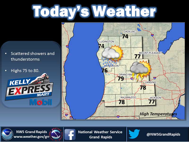
Showers and Thunderstorms Possible

An upper level low pressure system in the Upper Plains will lift slowly northeast today into Friday. This system will push a cold front through the region today. Thus some more showers and thunderstorms will be possible. A weak area of high pressure moves in tonight into Friday. This system will support less in the way of showers and thunderstorms. A stronger low pressure system could move in over the weekend resulting in additional showers and thunderstorms. Today:  A 50 percent chance of showers and thunderstorms. Mostly cloudy, with a high near 85. Southwest wind around 8 mph. Tonight:  Mostly clear, with a low around 64. Southwest wind 5 to 8 mph. Friday:  A 40 percent chance of showers and thunderstorms, mainly after 2pm. Mostly sunny, with a high near 87. Southwest wind 6 to 10 mph, with gusts as high as 18 mph. Saturday:  A 40 percent chance of showers and thunderstorms. Mostly cloudy, with a high near 87. South southwest wind 6 to 10 mph. Yesterday’s high temperature in Jackson was 87 at 4:25 PM.  The low was 68 at 11:59 PM. Normal high for today is 79.  The record low is 42, set in 1999.  The record…

Read more

Continued Warm, Possible Showers

A warm front developing in Northern Indiana will lift northward today through Southwest Lower Michigan. A cold front located in the Upper Plains will weaken as it tracks east today and pushes through the region later tonight and into Thursday. As a result... the warm weather will bring scattered showers and thunderstorms. A weak area of high pressure moves in for Friday. Then a potentially stronger low pressure system is forecasted to track through the Great Lakes Region over the weekend. Today:  Mostly cloudy with a 50 percent chance of showers and thunderstorms. Highs in the upper 80s. Southeast winds 5 to 10 mph. Gusts up to 20 mph in the afternoon. Tonight:  Showers and thunderstorms likely. Lows in the upper 60s. South winds 5 to 10 mph. Gusts up to 20 mph in the evening. Chance of rain 70 percent. Thursday:  Showers and thunderstorms likely until midday, then a chance of showers and thunderstorms in the afternoon. Highs in the mid 80s. Southwest winds 5 to 10 mph becoming west in the afternoon. Gusts up to 20 mph. Chance of rain 60 percent. Friday:  Mostly sunny until midday then becoming partly sunny. A 40 percent chance of showers and…

Read more

Continued Hot; Possible Showers

A nearly stationary front will remain over the region through tonight. This system will lift northward as a warm front on Wednesday. A cold front will push in from the west on Thursday. As a result...there will be scattered showers and thunderstorms around over the next couple of days. Overall much of the region will still see unseasonably warm temperatures. Today:  A 40 percent chance of showers and thunderstorms, mainly after 11am. Partly sunny and hot, with a high near 91. Heat index values as high as 95. West northwest wind 7 to 9 mph. Tonight:  A 40 percent chance of showers and thunderstorms, mainly before 11pm. Mostly cloudy, with a low around 67. East wind around 7 mph. Wednesday:  A 40 percent chance of showers and thunderstorms. Mostly cloudy, with a high near 86. Southeast wind 5 to 8 mph. Thursday:  Showers and thunderstorms likely, mainly between 9am and 3pm. Mostly cloudy, with a high near 85. Southwest wind 5 to 7 mph. Chance of precipitation is 60% Yesterday’s high temperature in Jackson was 90 at 4:42 PM.  The low was 68 at 5:35 AM. Normal high for today is 78.  The record low is 42, set in 1965. …

Read more

Sunny and Hot

A weak cold front will slip down from the north today and stall out over the region tonight through Wednesday. A moist airmass will follow into the region and along this front. This should result in showers and thunderstorms at times. Some of those storms could be strong and contain locally heavy rainfall.  Very warm conditions will persist south of this front while closer to seasonable temperatures will exist to the north. Today:  Sunny and hot, with a high near 91. West southwest wind 11 to 15 mph, with gusts as high as 24 mph. Tonight:  A 20 percent chance of showers and thunderstorms. Partly cloudy, with a low around 72. Southwest wind 5 to 7 mph. Tuesday:  A 50 percent chance of showers and thunderstorms. Partly sunny, with a high near 89. Southwest wind around 6 mph. Wednesday:  A 40 percent chance of showers and thunderstorms. Mostly cloudy, with a high near 84. East southeast wind 5 to 7 mph. Yesterday’s high temperature in Jackson was 89 at 3:53 PM.  The low was 69 at 5:32 AM. Normal high for today is 78.  The record low is 40, set in 1985.  The record high is 92, set in 1956…

Read more

Continued Sunny and Hot

A large area of high pressure over the mid Atlantic will continue to produce south to southwest winds here in lower Michigan over the next couple of days. This will act to keep the weather unseasonably warm. A front will slowly approach the region over the next couple of days from the northwest. This system will result in increasing chances for showers and thunderstorms…some of which could be severe. Today:  Sunny and hot, with a high near 90. Southwest wind around 15 mph, with gusts as high as 24 mph. Tonight:  Mostly clear, with a low around 69. South southwest wind 8 to 11 mph. Monday:  Sunny and hot, with a high near 92. Southwest wind 9 to 13 mph, with gusts as high as 22 mph. Yesterday’s high temperature in Jackson was 86 at 5:08 PM.  The low was 59 at 5:12 AM. Normal high for today is 78.  The record low is 36, set in 1972.  The record high is 92, set in 1973. No precipitation yesterday.  Month to date rainfall:  0.56 inches. Sunrise today at 6:01 AM EDT.  Sunset at 9:14 PM EDT.

Read more

Windy and Warm

Winds will increase today as low pressure deepens across southern Canada. Some gusts close to 40 mph can be expected by this afternoon. Warmer and more humid air will arrive for Sunday and Monday and thunderstorms will possible across central Lower Michigan. The storms should become widespread on Wednesday as a cold front moves in. Today: Sunny, with a high near 86. Southwest wind 9 to 18 mph, with gusts as high as 29 mph. Tonight:  Mostly clear, with a low around 66. South southwest wind around 16 mph, with gusts as high as 24 mph. Sunday:  Mostly sunny, with a high near 89. Southwest wind around 15 mph, with gusts as high as 25 mph. Monday:  Sunny and hot, with a high near 90. Southwest wind 13 to 16 mph, with gusts as high as 26 mph. Yesterday’s high temperature in Jackson was 82 at 5:02 PM.  The low was 55 at 2:36 AM. Normal high for today is 77.  The record low is 34, set in 1988.  The record high is 92, set in 1999. No precipitation yesterday.  Month to date rainfall:  0.56 inches. Sunrise today at 6:01 AM EDT.  Sunset at 9:14 PM EDT.

Read more

Scattered Showers

Weak low pressure will move through today bringing scattered showers and isolated thunderstorms. The rain should end this evening with fair weather for the weekend. Today: Isolated showers, then a chance of showers and thunderstorms after 8am. Mostly cloudy, with a high near 79. South southwest wind 7 to 16 mph. Chance of precipitation is 50%. Tonight:  A 10 percent chance of showers before 7pm. Partly cloudy, with a low around 57. West southwest wind 6 to 13 mph. Saturday:  Mostly sunny, with a high near 85. Southwest wind 9 to 18 mph, with gusts as high as 29 mph. Sunday:  A 20 percent chance of showers after 2pm. Mostly sunny, with a high near 89. West southwest wind around 16 mph, with gusts as high as 26 mph. Yesterday’s high temperature in Jackson was 79 at 4:47 PM.  The low was 44 at 3:54 AM. Normal high for today is 77.  The record low is 36, set in 1988.  The record high is 92, set in 2068. No precipitation yesterday.  Month to date rainfall:  0.56 inches. Sunrise today at 6:01 AM EDT.  Sunset at 9:13 PM EDT.

Read more

Fair Today, Showers Possible Tonight

High pressure will provide one more day of fair weather but clouds and some showers could be moving in this evening along a weak front. Showers and a few thunderstorms will linger into Friday before fair weather returns for Saturday. Today: Sunny, with a high near 77. Light and variable wind. Tonight:  A 20 percent chance of showers after 2am. Partly cloudy, with a low around 55. Calm wind becoming south southwest around 5 mph after midnight. Friday:  A 30 percent chance of showers and thunderstorms, mainly after 8am. Partly sunny, with a high near 77. South wind 8 to 14 mph, with gusts as high as 23 mph. Saturday:  Mostly sunny, with a high near 84. West southwest wind 11 to 17 mph. Yesterday’s high temperature in Jackson was 75 at 4:44 PM.  The low was 49 at 4:15 AM. Normal high for today is 77.  The record low is 38, set in 1949.  The record high is 91, set in 2005. No precipitation yesterday.  Month to date rainfall:  0.56 inches. Sunrise today at 6:01 AM EDT.  Sunset at 9:13 PM EDT.

Read more

Fair Weather Continues

High pressure will bring fair weather through Thursday. A weak cold front could bring some showers and thunderstorms late Thursday night and Friday with fair weather returning for the weekend. Today:  Sunny, with a high near 74. Northeast wind 5 to 13 mph, with gusts as high as 21 mph. Tonight:  Mostly clear, with a low around 50. Northeast wind 5 to 7 mph becoming light and variable in the evening. Thursday:  Sunny, with a high near 76. Light and variable wind. Yesterday’s high temperature in Jackson was 74 at 3:30 PM.  The low was 48 at 5:11 AM. Normal high for today is 76.  The record low is 34, set in 1988.  The record high is 101, set in 1971. No precipitation yesterday.  Month to date rainfall:  0.56 inches. Sunrise today at 6:02 AM EDT.  Sunset at 9:12 PM EDT.

Read more

Sunny and Breezy

High pressure will bring dry weather through Thursday with low humidity. A weak front may bring a few showers by late Thursday night into Friday followed by more fair weather for the weekend. Today:  Mostly sunny, with a high near 70. Breezy, with a north wind 9 to 14 mph increasing to 15 to 20 mph in the afternoon. Winds could gust as high as 29 mph. Tonight:  Mostly cloudy, with a low around 50. North northeast wind 7 to 16 mph, with gusts as high as 24 mph. Wednesday:  Mostly sunny, with a high near 71. Northeast wind 6 to 14 mph, with gusts as high as 22 mph. Yesterday’s high temperature in Jackson was 71 at 4:45 PM.  The low was 53 at 11:59 PM. Normal high for today is 76.  The record low is 36, set in 1998.  The record high is 92, set in 1999. A trace of precipitation yesterday.  Month to date rainfall:  0.56 inches. Sunrise today at 6:02 AM EDT.  Sunset at 9:12 PM EDT.

Read more

Contact Us

152 West Michigan Avenue
Jackson, MI 49201
517-787-8817
viewermail@jtv.tv

Back To Top