
Quantcast
Skip to content

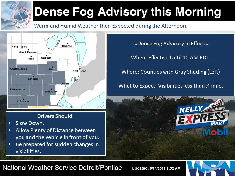
Fog Advisory Early, Then Summer-Like Weather

The National Weather Service in Grand Rapids has issued a Dense Fog Advisory...which is in effect until 9 AM EDT this morning. Areas of dense fog will lift this morning and high pressure will bring fair weather through the end of the week. The next chance for rain will be on Sunday afternoon as a cold front approaches. Today:  Partly sunny. Areas of fog until midday. Highs in the upper 70s. Light winds. Tonight:  Mostly clear. Patchy fog overnight. Lows in the mid 50s. Light winds. Friday:  Mostly sunny. Highs around 80. Light winds becoming south 5 to 10 mph in the afternoon. Friday Night:  Mostly clear. Lows in the upper 50s. Southeast winds around 5 mph. Saturday:  Sunny. Highs in the lower 80s. South winds around 5 mph. Saturday Night:  Mostly clear. Lows around 60. Sunday:  Mostly sunny until midday then becoming partly sunny. Highs in the lower 80s. Yesterday’s high was 72 at 4:39 PM.  The low was 53 at 1:25 AM. Average temperature for today is 74.  The record high is 90 set in 1976, record low is 33 set in 1975. 0.00 inches of of precipitation yesterday.  Total precipitation for the month:  0.56 inches.    Sunrise…

Read more

Chance of Showers

Weakening low pressure, formally Irma, will approach from  the south today and tonight and bring some cloudiness and perhaps a few showers to southern lower Michigan. Otherwise high pressure and above normal temperatures will dominate our weather through the coming weekend. Today:  Mostly cloudy with a 30 percent chance of rain showers. Highs in the mid 70s. Southeast winds around 10 mph becoming south in the afternoon. Tonight:  Mostly cloudy. A 20 percent chance of rain showers in the evening. Patchy fog overnight. Lows in the lower 50s. Light winds. Thursday:  Partly sunny until midday then becoming mostly sunny. Highs in the upper 70s. Light winds. Thursday Night:  Mostly clear. Patchy fog overnight. Lows in the mid 50s. Light winds. Friday:  Sunny. Highs around 80. Light winds. Friday Night:  Mostly clear. Lows in the upper 50s. Saturday:  Sunny. Highs in the lower 80s. Saturday Night:  Mostly clear. Lows around 60. Sunday:  Mostly sunny with a 20 percent chance of showers. Highs in the lower 80s. Yesterday’s high was 78 at 3:18 PM.  The low was 44 at 4:06 AM. Average temperature for today is 74.  The record high is 93 set in 1952, record low is 33 set in 1964…

Read more

Hazy Sunshine with Light Winds

Tropical Depression Irma will bring some cloudiness to the region the next couple days as it advances north and continues to weaken. A few showers will be possible on Wednesday as it tracks through the Ohio Valley, then decreasing clouds will follow Thursday as the system dissipates and high pressure builds back into the region. The upcoming weekend looks quite summerlike with highs around 80 and more humid conditions developing. Today:  Partly sunny. Highs in the upper 70s. Light winds becoming east 5 to 10 mph in the afternoon. Tonight:  Partly cloudy. A 30 percent chance of rain showers overnight. Lows in the mid 50s. East winds around 5 mph. Wednesday:  Mostly cloudy with a 20 percent chance of rain showers. Highs in the mid 70s. Southeast winds around 5 mph becoming south in the afternoon. Wednesday Night:  Partly cloudy with a 20 percent chance of rain showers. Lows in the mid 50s. Light winds. Thursday:  Partly sunny until midday then becoming mostly sunny. Highs in the mid 70s. Light winds. Yesterday’s high was 73 at 4:01 PM.  The low was 42 at 6:35 AM. Average Temperature for today is 74.  The record high is 94 set in 1952, record…

Read more

Sunny and Pleasant

High pressure will continue to provide sunny and pleasant weather today and Tuesday, with warmer high temperatures in the mid to upper 70s. Some cloudiness, and perhaps a few showers, will spread into the region on Wednesday as the remains of Irma moves through the Ohio Valley Region. Above normal temperatures will continue into next weekend. Today:   Sunny. Highs in the mid 70s. Light winds. Tonight:  Partly cloudy. Lows in the upper 40s. Light winds. Tuesday:  Sunny. Highs in the upper 70s. East winds 5 to 10 mph. Tuesday Night:  Partly cloudy in the evening, then mostly cloudy with a 30 percent chance of rain showers overnight. Lows in the mid 50s. East winds around 5 mph. Wednesday:  Mostly cloudy with a 30 percent chance of rain showers. Highs in the mid 70s. Southeast winds around 5 mph. Wednesday Night:  Normal high for today is 75.  The record low is 37, set in 1993.  The record high is 93, set in 1978.  Yesterday’s high was 69 at 3:56 PM.  The low was 40 at 6:10 AM. 0.00 inches of of precipitation yesterday.  Total precipitation for the month:  0.56 inches.    Sunrise today at 7:14 AM EDT.  Sunset at 7:54…

Read more

Mostly Sunny and Pleasant

High pressure will remain anchored over the Great Lakes Region through at least Tuesday. A slight chance of showers will arrive on Wednesday as the remains of Irma lift northward. One more day of seasonal temperatures can be expected today then above normal temperatures are forecast through the coming week. Today:  Sunny. Highs in the upper 60s. Light winds. Tonight:  Clear. Lows in the mid 40s. Light winds. Monday:  Sunny. Highs in the lower 70s. Light winds. Monday Night:  Mostly clear. Lows in the upper 40s. Tuesday:  Mostly sunny. Highs in the upper 70s. Normal high for today is 76.  The record low is 38, set in 1979.  The record high is 92, set in 1983.  Yesterday’s high was 67 at 3:22 PM.  The low was 49 at 6:30 AM. 0.00 inches of of precipitation yesterday.  Total precipitation for the month:  0.56 inches.    Sunrise today at 7:12 AM EDT.  Sunset at 7:58 PM EDT.

Read more

Sunny and Pleasant Weekend throughout Michigan

Low pressure will move out today and be replaced by high pressure  which will sit over the area for several days. Scattered showers will end this morning then a lengthy stretch of nice weather can be expected into next week. Temperatures will recover to near normal this weekend and to above normal next week. Today:   Partly sunny until midday then clearing. Patchy fog early. highs in the mid 60s. North winds 5 to 10 mph. Tonight:  Mostly clear. Lows around 40. Light winds. Saturday:  Sunny. Highs in the upper 60s. Northeast winds 5 to 10 mph. Saturday Night:  Mostly clear. Lows in the upper 30s. Light winds. Sunday:  Sunny. Highs in the upper 60s. Light winds. Sunday Night:  Clear. Lows in the mid 40s. Monday:  Sunny. Highs in the mid 70s. Normal high for today is 76.  The record low is 36, set in 1979.  The record high is 100, set in 1978.  Yesterday’s high was 64 at 12:45 PM.  The low was 44 at 5:47 AM. 0.54 inches of of precipitation yesterday.  Total precipitation for the month:  0.56 inches.    Sunrise today at 7:11 AM EDT.  Sunset at 7:59 PM EDT.

Read more

Cool and Cloudy

More showers with some thunderstorms are expected today and overnight. This activity will shift slowly to the east with perhaps some showers lingering Friday morning across far southwest Lower Michigan. Dry conditions are then expected from Friday through Tuesday with gradually increasing temperatures. Highs in the 60s today through Saturday will reach the 70s Sunday through Wednesday. Today:   Rain showers likely and a chance of thunderstorms in the afternoon. Highs in the lower 60s. West winds 5 to 10 mph. Chance of rain 70 percent. Tonight:  Mostly cloudy. Rain showers likely in the evening, then a chance of rain showers overnight. Lows in the upper 40s. West winds around 5 mph. Chance of rain 30 percent. Friday:  Mostly sunny. Highs in the mid 60s. North winds 5 to 10 mph. Friday Night:  Mostly clear. Lows around 40. Light winds. Saturday:  Sunny. Highs in the mid 60s. Northeast winds around 10 mph. Saturday Night:  Mostly clear. Lows in the lower 40s. Sunday:  Sunny. Highs in the upper 60s. Normal high for today is 77.  The record low is 36, set in 1986.  The record high is 94, set in 1978.  Yesterday’s high was 65 at 4:22 PM.  The low was…

Read more

Cool and Unsettled Weather

Cool and unsettled weather will continue through Thursday night with highs generally in the lower 60s. Showers and some thunderstorms will be particularly common near the lakeshore and over Lake Michigan. Dry conditions are then expected from Friday through Tuesday with highs climbing back into the 70s by Sunday. Today:   A chance of rain showers until midday, then rain showers likely and a slight chance of thunderstorms in the afternoon. Highs in the mid 60s. Light winds becoming northwest 5 to 10 mph in the afternoon. Chance of rain 60 percent. Tonight:  Partly cloudy. A 30 percent chance of rain showers in the evening. Lows in the mid 40s. Light winds. Thursday:  Mostly cloudy with a 50 percent chance of rain showers. Highs in the lower 60s. West winds 5 to 10 mph. Thursday Night:  Mostly cloudy in the evening then becoming partly cloudy. A 50 percent chance of rain showers. Lows in the mid 40s. West winds around 5 mph. Friday:  Mostly sunny. Highs in the mid 60s. North winds 5 to 10 mph. Normal high for today is 77.  The record low is 35, set in 1962.  The record high is 94, set in 1954.  Yesterday’s high…

Read more

Cooler for the Week

Much cooler temperatures are expected the rest of the week with highs in the 60s. With these cooler temperatures will be scattered rain showers. Drier conditions are expected this weekend with highs in the 70s by Sunday and Monday. Today:   Mostly sunny. A 20 percent chance of rain showers until midday. Highs in the upper 60s. West winds 5 to 15 mph. Tonight:  Partly cloudy. Lows in the mid 40s. Light winds. Wednesday:  Mostly cloudy. A slight chance of rain showers until midday, then a chance of showers and thunderstorms in the afternoon. Highs in the mid 60s. Light winds. Chance of rain 50 percent. Wednesday Night:  Partly cloudy. Lows in the mid 40s. Northwest winds around 5 mph. Thursday:  Mostly cloudy with a 50 percent chance of rain showers. Highs in the mid 60s. West winds 5 to 10 mph. Normal high for today is 77.  The record low is 40, set in 1984.  The record high is 95, set in 1954.  Yesterday’s high was 85 any 2:31 PM.  The low was 56 at 10:43 PM. 0.02 inches of precipitation yesterday.  Total precipitation for the month:  0.02 inches.    Sunrise today at 7:08 AM EDT.  Sunset at 8:04…

Read more

Afternoon Labor Day Showers

Showers and thunderstorms are expected mainly this afternoon.  Some storms could even become severe farther southeast towards Jackson before precipitation completely exits the area this evening. This will be followed by cool temperatures and some rain showers near the lakeshore with highs in the 60s for much of the week. Today:   Sunny until midday, then showers likely and a chance of thunderstorms in the afternoon. Some thunderstorms may be severe. Highs in the lower 80s. Southwest winds 10 to 20 mph with gusts to around 35 mph. Chance of rain 70 percent. Tonight:  Partly cloudy. A 50 percent chance of rain showers in the evening. Lows in the lower 50s. West winds 5 to 10 mph. Tuesday:  Mostly sunny until midday then becoming partly sunny. Highs around 70. West winds 5 to 15 mph. Tuesday Night:  Partly cloudy. Lows in the mid 40s. West winds 5 to 10 mph in the evening becoming light. Wednesday:  Partly sunny with a 40 percent chance of rain showers. Highs in the mid 60s. Light winds. Normal high for today is 77.  The record low is 38, set in 1974.  The record high is 91, set in 1973.  Yesterday’s high was 78 any…

Read more

Contact Us

152 West Michigan Avenue
Jackson, MI 49201
517-787-8817
viewermail@jtv.tv

Back To Top